- Stay Connected

Socialize

 Abraham Lincoln
If given the truth, the people can be depended upon to meet any national crisis...
Abraham Lincoln
If given the truth, the people can be depended upon to meet any national crisis...

 Guildford news...
for Guildford people, brought to you by Guildford reporters - Guildford's own news service
Guildford news...
for Guildford people, brought to you by Guildford reporters - Guildford's own news service
Where Is This? No.249
Published on: 2 Mar, 2017
Updated on: 2 Mar, 2017
By David Rose
The watercolour painting featured as last week’s mystery vintage picture showed a view of Guildford from the River Wey with Shalford Meadows to the right.
A number of readers correctly identified it, including some queries as to the accuracy of the actual view – put it down to artist licence.
However, Chris Townsend in her reply added some interesting details about the artist Florence Biddle, while Doug and Bill remarked on it being painted a long time ago as there are no speed boats in the picture. Hey guys: where do you moor your boat?
There was just one reader who correctly identified the piece of artwork in the quirky picture. It can be found in Guildford Library.
It was one of a number of such pieces that formed the decorations that were strung up in the High Street at the time of the Queen’s silver jubilee in 1977.
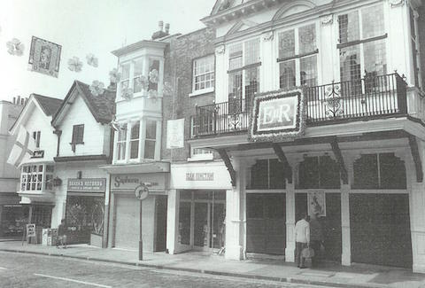
Guildford High Street in 1977 with decorations to mark the Queen’s silver jubilee. Note the tableau to the top left.
Here is a picture of it in situ featured in Stanley Newman’s book The Changing Face of Guildford.
To see the replies and all the details, click here for last week’s post.
Where is this? What’s gone and what remains? Click to enlarge image.
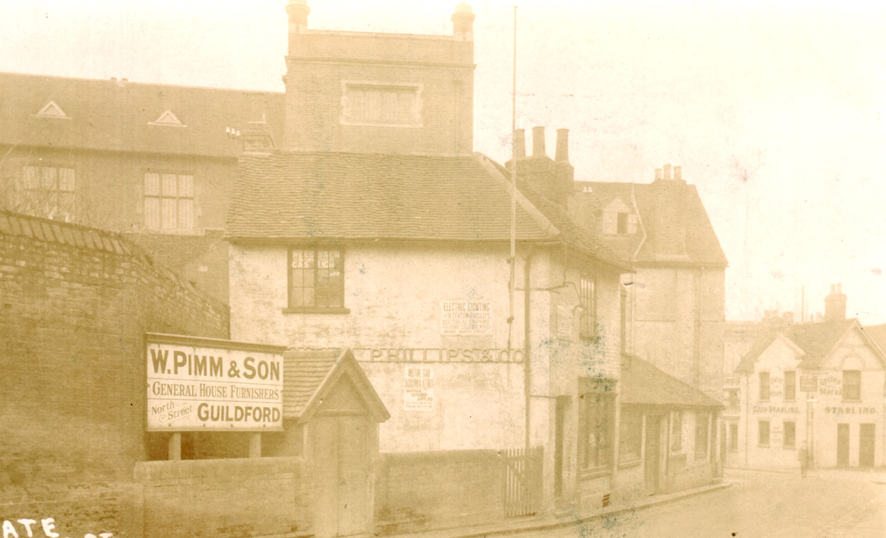
This week’s vintage image must date from the very early 1900s. Some buildings remain, some have long gone. Can you work out where this is in the town centre?
Do you recognise this location? Click to enlarge image.
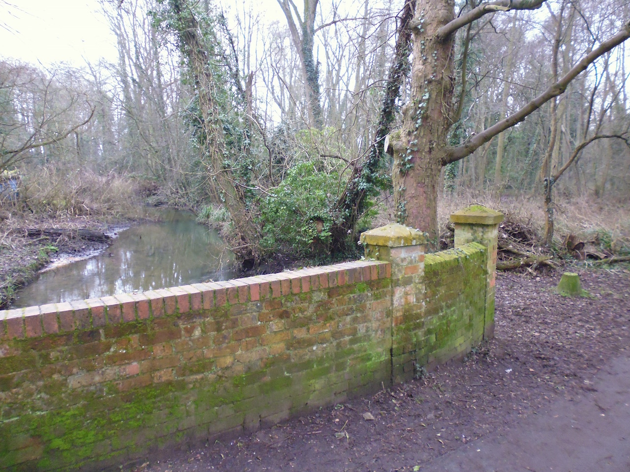
The quirky image was taken by Martin Giles and shows a brick wall beside what I believe to be a bit of a backwater of the River Wey. It’s not too far from the town centre and also near some football pitches. Do you recognise this location? Anything in view that look’s interesting?
If you think you know the answers, please leave a reply in the box below. The answers, along with the next pair of images, will be published at about the same time next week.
Share This Post


Responses to Where Is This? No.249
Leave a Comment Please see our comments policy. All comments are moderated and may take time to appear. Full names, or at least initial and surname, must be given.

I'm living well for nothing at all! (See: No Trifling Matter: Magpie Trapped in Godalming Sainsbury’s)


Next stop, Debt Chasm! (See: We Should All Be Outraged About the Failure to Deal with Legacy Debt)


John Lomas
March 3, 2017 at 12:10 am
The building in the left background of the old picture was the Abbot’s School which now houses, according to Streetview, the Edinburgh Woolen Mill shop, at least on the ground floor.
I see their address is given as the Old Cloth Hall, so was that a use prior to it becoming a school?
The white building on the far right was the Horse and Groom pub, now the Sofa Workshop.
The foreground buildings, where Abbot’s Hospital gardens are now, disappear from old maps between 1896 and 1916.
The same period saw the development of the Northgate House site into one building which was Pimm’s whose advertisement is interesting.
Did they start on that side and then move their shop to the opposite side?
Dave Middleton
March 3, 2017 at 11:17 am
The street scene is the top of North Street, taken from roughly outside the night club formerly known a Cinderella’s (I think it’s called “Vinyl” now?)
The building to the right of the picture is the former Horse and Groom pub, the scene of one of the terrible IRA Guildford pub bombings – a memorial to those who were killed by the bomb in the Horse and Groom is set into a wall nearby in the little town park that is Quaker’s Acre, next to the Library.
On the left-hand side of the road, the building with the window open in the roof top window, is the long gone Crown pub which was once attached to the north side of the Abbot’s cloth hall that currently houses the Edinburgh Wollen Mill shop.
The pub, together with the low building behind it and Phillips & Co’s building, were demolished to allow the top of North Street to be widened in 1907.
The high brick wall was then the back wall of the Abbott’s Hospital grounds.
No idea where the bridge is but is that a small “Dragon’s Tooth” anti-tank defence in shot, just past the end of the bridge?
Mike Williams
March 3, 2017 at 2:35 pm
In the 1977 picture of the Guildhall what caught my attention was the newspaper bins for the Evening News and Standard where Task used to stand outside the Bull’s Head pub. He’s not there so it must be before noon or a Sunday.
But swiftly moving on to the Pimm’s photo.
I think this is at the rear of Abbot’s Hospital where the extension now stands. Pimm’s store was opposite, with the bombed Horse and Groom pub in the background maybe.
I wonder what Phillips did?
Martin’s backwater is behind Shalford Church somewhere I think, perhaps close to the footpath through the waterworks to the the Sea Horse pub.
Margaret Cole
March 7, 2017 at 6:07 pm
The first picture of Pimms Furnishers in the grounds of Abbot’s Hopital top of North Street.
I see where the Horse and Groom pub opposite was and Pimms changed sides. I think a pub was demolished also to widen the road.
Second picture showing a stream which I hazard a guess and say somewhere in Shalford Park, could be, who knows?
Bill and Doug Stanniforth
March 8, 2017 at 5:13 pm
It’s North Street looking toward Abbot’s Hospital.
The bridge is at the end of Shalford Park near the water treatment plant, the river is the majestic Tillingbourne as it meanders its way toward the River Wey.
Chris Townsend
March 8, 2017 at 7:54 pm
The vintage image is of the top of North Street. The tower remains, built in 1891, and the Old Cloth Hall.
On the left is the garden wall of Abbot’s Hospital.
In the centre was the shop of Henry Fentum Phillips (1871-1928), electrical engineer and former Mayor of Guildford. Behind it was the Crown, demolished in 1907.
On the right is the former Horse and Groom pub. The advertisement for Pimm’s relates to their premises across the street.
There’s a path through woods with a footbridge over a stream just north of the A3 near the Spectrum football ground. I’m hoping that’s the one. The interesting feature is the tank trap.
Brian Holt
March 8, 2017 at 9:15 pm
The vintage photo shows the top of North Street and the rear of Abbot’s Hospital.
Most of this area was once gardens that was replaced by the extension of Abbot’s Hospital in 1983.
The tall building is still there – more latterly Clark’s College, and now the Edinburgh Woollen Mill shop.
Also the Horse and Groom pub is in the photo.
The quirky picture shows bridge on the Shalford Road over the Tillingbourne stream that flows at the side of Shalford Park into the River Wey.