 Abraham Lincoln
If given the truth, the people can be depended upon to meet any national crisis...
 Guildford news...
for Guildford people, brought to you by Guildford reporters - Guildford's own news service
Where Is This? No.258
Published on: 4 May, 2017
Updated on: 4 May, 2017
By David Rose
Perry Hill Green at Worplesdon and Philps’ motor-garage and store was featured as last week’s vintage picture.
Easily spotted by a number of readers, and in answer to Mike Williams enquiring whether there are members of the Philps family living Worplesdon, the answer is yes.
And thank to Chris Townsend who added details about the family in Worplesdon in her reply.
The brickwork in the quirky picture is actually at the entrance to Ganghill in London Road, and not Abbotswood, which a couple of readers suggested, although very similar.
Click here for last week’s post and all the replies.
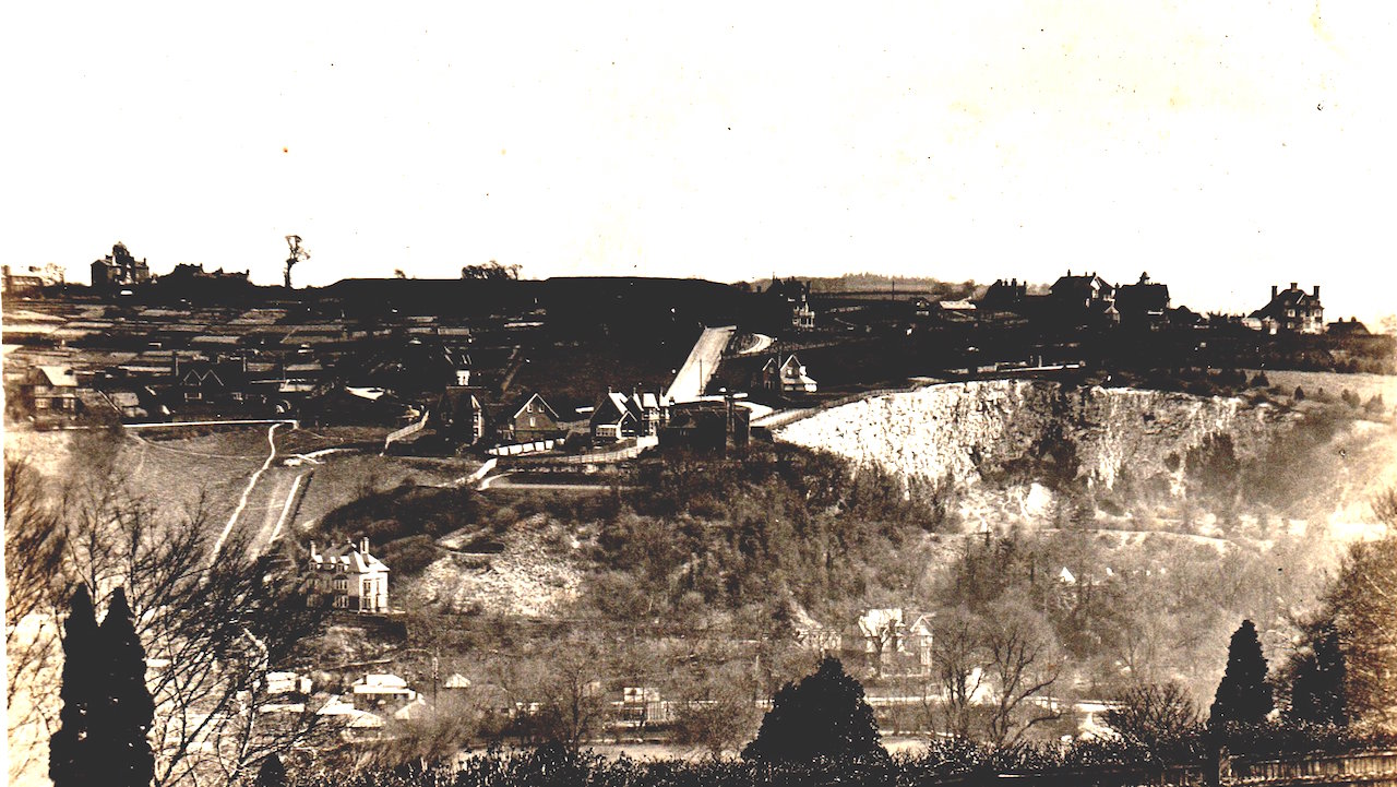
This week’s mystery vintage picture is a postcard view and the card itself is postmarked October 16, 1913. The writer notes that they have been staying in Guildford and the weather has been lousy!
We have featured similar views, but I don’t think this actual one that is rather interesting – once you have worked out what you are looking across to and where. Click to enlarge it in a new window for a better view.
What can be seen and any suggestions as to where the photographer was standing?
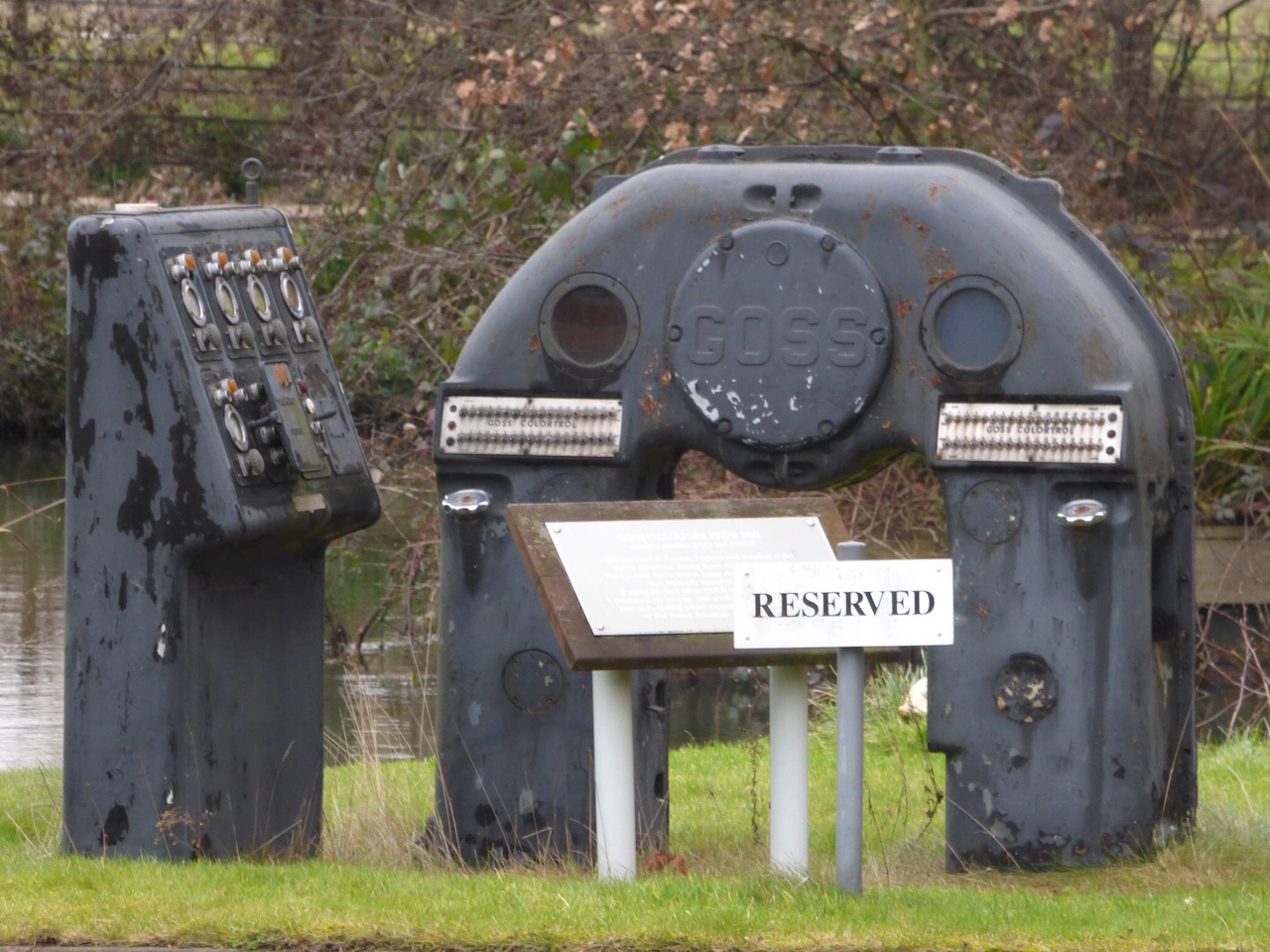
The quirky picture this time features some old machinery placed as kind of artwork or an industrial reminder. What was it used for and where can it be found?
If you think you know the answers and can add any extra details, please leave a reply in the box below.
The answers, along with the next pair of images, will be published at about the same time next week.
Responses to Where Is This? No.258
Leave a Comment Cancel replyPlease see our comments policy. All comments are moderated and may take time to appear.
Recent Articles
- Guildford Institute’s Crowdfunding Project for Accessible Toilet in its New Community and Wellbeing Centre
- Letter: Guildford – Another Opportunity Missed?
- Letter: GBC’s Corporate Strategy – Where Is the Ambition?
- My Memories of John Mayall at a Ground-breaking Gig in Guildford Nearly Six Decades Ago
- Westborough HMO Plans ‘Losing the Heart of the Street’ Says Resident
- College Invests to Boost Surrey’s Economy and Close Digital Skills Gap
- Community Lottery Brings Big Wins for Local Charities
- GBC Housing Plan Promises ‘A Vibrant Urban Neighbourhood’ Near Town Centre
- Hospital Pillows ‘Shortage’ at the Royal Surrey
- Updated: Caravans Set Up Camp at Ash Manor School


Recent Comments
- Ian Macpherson on Updated: Main Guildford to Godalming Road Closed Until August 1
- Sara Tokunaga on GBC Housing Plan Promises ‘A Vibrant Urban Neighbourhood’ Near Town Centre
- Michael Courtnage on Daily Mail Online Reports Guildford Has Highest-paid Council Officer
- Alan Judge on GBC Housing Plan Promises ‘A Vibrant Urban Neighbourhood’ Near Town Centre
- John Perkins on GBC Housing Plan Promises ‘A Vibrant Urban Neighbourhood’ Near Town Centre
- S Collins on GBC Housing Plan Promises ‘A Vibrant Urban Neighbourhood’ Near Town Centre
Search in Site
Media Gallery
Dragon Interview: Local Artist Leaves Her Mark At One of England’s Most Historic Buildings
January 21, 2023 / No Comment / Read MoreDragon Interview: Lib Dem Planning Chair: ‘Current Policy Doesn’t Work for Local People’
January 19, 2023 / No Comment / Read MoreA3 Tunnel in Guildford ‘Necessary’ for New Homes, Says Guildford’s MP
January 10, 2023 / No Comment / Read More‘Madness’ for London Road Scheme to Go Ahead Against ‘Huge Opposition’, Says SCC Leader
January 6, 2023 / No Comment / Read MoreCouncillor’s Son Starts Campaign for More Consultation on North Street Plan
December 30, 2022 / No Comment / Read MoreCounty Council Climbs Down Over London Road Works – Further ‘Engagement’ Period Announced
December 14, 2022 / No Comment / Read MoreDragon Interview: GBC Reaction to the Government’s Expected Decision to Relax Housing Targets
December 7, 2022 / No Comment / Read MoreHow Can Our Town Centre Businesses Recover? Watch the Shop Front Debate
May 18, 2020 / No Comment / Read More


John Lomas
May 5, 2017 at 12:20 am
This is the Great Quarry, the house at the bottom of the picture right of centre is the one at the junction of Shalford Road and Great Quarry.
The white house to the left of that appears to be at the bottom of Abbot Road, (just visible with a bright white “footpath” alongside it,) this house has now been replaced by modern builds.
I think Highmount and possibly Echo Pit Lodge are amongst the right-hand side skyline houses, I don’t think the view goes far enough east to see Chantries.
The angled road dropping down the centre of the picture is Warwicks Bench.
John Gibson
May 5, 2017 at 9:14 am
I think the Great Quarry above Shalford Meadows and power switching gear at Stoke Mill.
The chalk from the quarry was loaded on to barges on the Godalming Navigation where Guildford Rowing Club is now situated – part of the wharf wall can still be seen.
Bernard Parke
May 5, 2017 at 10:34 am
1) The Chalk Quarry looking towards the Fort Road direction
2) Outside of the Surrey Advertiser office.
John Lomas
May 6, 2017 at 2:10 pm
I think the machinery is the triangular feature in this overhead view of Stoke mill. between the car park and the mill branch of the river.
https://goo.gl/maps/Qh6sJoSBeNG2
I would suspect that it is part of a later turbine drive to power the mill. Or did the mill become a power generator for the grid in it;s later life?
Eddie Ward
May 6, 2017 at 10:12 pm
The old photograph is where Great Quarry and Abbot Road are now.
Possibly taken from Flower Walk or Artington Walk.
As for the second one, that is a complete mystery!
Brian Holt
May 10, 2017 at 8:07 pm
The quarry in Chantry View Road. In the bottom right-hand corner you can just see the River Wey.
Above the tree in the middle of the picture at the bottom is the house on the corner of the Great Quarry. To the left of that the house that was once a hotel at the junction of Great Quarry and Abbot Road.
Left of that is Racks Close, the houses above and the quarry is Warwicks Bench Road.
Bottom left corner is Leroy’s boathouse with the Jolly Farmer pub, between the small trees.
I think photo taken from the top of the Mount or Guildown Road as the angle is wrong if taken from top of St Catherine’s.
The old machinery is by the weir just past the Guildford Rowing Club’s clubhouse.
Chris Townsend
May 11, 2017 at 4:16 pm
The postcard view shows the Warwicks Bench area, seen from Guildown, possibly from the old Mount Cemetery.
Old maps indicate much development of the area between 1896 and 1916; 20 plots of building land on the Southlands Estate, Warwicks Bench, were sold in 1906.
In the view, the roads and quarries are just chalk scars on the landscape.
The original Jolly Farmer pub (pre-1913) can be seen on Quarry Street, lower left of centre, with the boathouse buildings below it.
Beyond it, high above Quarry Street, is the one-time Quarry Edge Hotel at the foot of Abbot Road, and the large house on Quarry Street at the foot of Great Quarry is just right of centre.
Top left, at the top of Pewley Hill, is Semaphore House.
My guess is that the old machinery has great sentimental value to those who worked in newspaper printing, and it’s been relocated from the old Surrey Adverytiser buildings at Martyr Road to its present site (in the car park?) by the river at Stoke Mill. Am I anywhere near the mark?
Arthur Hill
November 6, 2020 at 5:03 pm
Having just started again to look at Chalk Quarries around Guildford, I would hazard the guess that the quarry is Guildford Great Quarry viewed from somewhere on The Mount. The flat-topped horizon, centre to centre left, should be Pewley Fort. The prominent road, centre (near vertical), could be Fort Road with Abbott Road leading off to the right and bending down.
Fort Road certainly points across the River Wey towards the top of The Mount. Then the apparent road in the foreground running down from the front of the large pale house, lower right, to the rear of the large house, lower centre, is the driveway continuing down from the bottom of Abbott Road to the bottom of Great Quarry.
The large house at this lower junction being Quarry Gate. As for the second image, these two redundant(?) pieces of equipment in the grounds of what, in my time in Guildford, was Stoke Mill.