- Stay Connected

Socialize

 Abraham Lincoln
If given the truth, the people can be depended upon to meet any national crisis...
Abraham Lincoln
If given the truth, the people can be depended upon to meet any national crisis...

 Guildford news...
for Guildford people, brought to you by Guildford reporters - Guildford's own news service
Guildford news...
for Guildford people, brought to you by Guildford reporters - Guildford's own news service
Where Is This? No.259
Published on: 11 May, 2017
Updated on: 11 May, 2017
By David Rose
The pictures seen here last week may have been a bit tricky for some readers to identify, but, as usual, the regulars recognised the features and added extra comments.
The vintage picture showed a view looking towards the Warwicks Bench area. The caption on the original postcard (which I cropped out) stated “View from The Mount, Guildford”.
However, I think the photographer must have been standing on the Guildown side.
Some of the replies to the quirky picture were not correct, while others were.
The old machinery can be found by some car parking spaces at the front of the Trinity Mirror newspaper offices (Surrey Advertiser) at Stoke Mill, off the Woking Road.
They are from the Goss Mark II Headliner press that was at the Advertiser’s offices and print works in Martyr Road.
The press was installed in 1962 and gave good service until it was used for the last time in about 1992 (I forget the exact date as I was working at the Surrey Herald in Chertsey at the time).
I returned to the Surrey Advertiser in 1994 and in 1999 we moved to Stoke Mill. Ray Gosling, one the production managers, organised the move and the furnishing of the offices. He did a great job and the whole operation went very smoothly.
By then, the newspaper group’s titles were being printed in Reading.
One feature, and I think I had a say in this, was that part of the old press that was laying dormant in the press hall at Martyr Road, would be saved and brought to Stoke Mill as a feature beside the mill buildings and the water course.
Those of us interested in the history and heritage of the newspaper were really pleased. I don’t know whether today’s large media groups would be bothered to do such a thing.
Do you recognise the location? Click to enlarge in a new window.
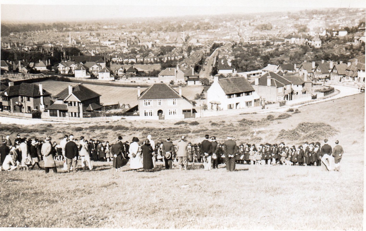
On to this week’s mysteries and there are two vintage images that go together and courtesy of Ben Darnton of Ben’s Collectors Records shop in Guildford. They came in a bundle of old pictures he bought in a charity shop. He has featured at least one of them on his Facebook page Guildford Past and Present, but I thought I would reproduce them here as the event shown is a bit of a mystery.
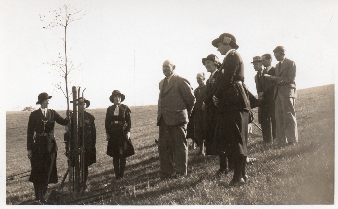
What’s going on? Click to enlarge in a new window.
Firstly, can you identify the location and secondly does anyone have an idea of what is going on?
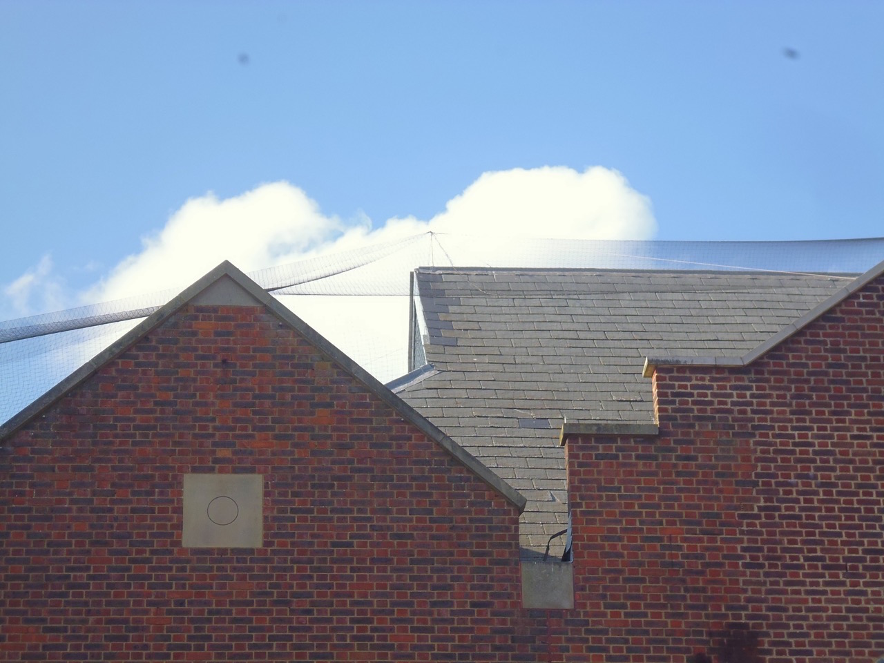
Part of a well known complex in Guildford town centre. Which one? Click to enlarge in a new window.
This week’s quirky picture was taken by Dragon editor Martin Giles and shows a building in Guildford town centre with some netting, presumably to stop birds congregating or nesting there. Do you know which building this is? It’s quite a large complex.
If you think you know the answers and can add some extra details, please leave a reply in the box below.
The answers, along with the next pair of images, will be published at about the same time next week.
Share This Post


Responses to Where Is This? No.259
Leave a Comment Please see our comments policy. All comments are moderated and may take time to appear. Full names, or at least initial and surname, must be given.

I'm living well for nothing at all! (See: No Trifling Matter: Magpie Trapped in Godalming Sainsbury’s)


Next stop, Debt Chasm! (See: We Should All Be Outraged About the Failure to Deal with Legacy Debt)


Kevin Blackburn
May 12, 2017 at 1:05 am
Looking down on, the then new, Wodeland Avenue.
John Lomas
May 12, 2017 at 6:25 am
The old pictures depict an event on the hill between Henley Fort and Wodeland Avenue.
The house in the centre of the picture appears to be around number 100 Wodeland Avenue (two houses, clockwise, from Plaegan House).
The playing field in the centre of the Wodeland Avenue loop is just behind that house and the playing field for the girls grammar school is a little further back.
The straight road visible to the right of that is the earlier section of Wodeland Avenue leading to Wherwell Road.
The second picture seems to show that this is a tree planting event of some significance to the Girl Guide movement. Gmaps, satellite view, shows a solitary tree on that slope even now, could this be the one planted all those years ago?
John Lomas
May 12, 2017 at 9:44 am
I think the quirky picture shows the bottom most gables of the Friary Centre on North Street seen from close to the Friary Street entrance.
Simon Nelson
May 12, 2017 at 3:47 pm
The vintage photo is a view from The Mount looking down on to Wodleland Avenue.
The junction of the Farnham Road which is out of shot would be on the left of the photo.
This looks like sometime in the 1930s. Tree planting to remember someone who was involved or a member of the Girl Guide movement possibly?
The quirky photo looks like one end of Guildford Crown Court, but not sure.
Anthony (Tony) Bullen
May 13, 2017 at 9:48 pm
The tree planting is on the edge of the downs opposite 100 Woodland Avenue Guildford.
Having looked at the site on Google it appears to be behind a parking notice.
The site looks as though it may have been enclosed as it is fenced. My guess it is about 1935 to commentate the 25th anniversary of the Girl Guides which was established for girls as the boys had the Scouts. I gather Baden Powell asked his Sister Agnes Baden Powell to take charge. Alternatively the land could have been donated to be used for guides to camp.
I found the photo to be of great interest. The land behind the house was where as a pupil at St John’s School in Farnham Road I went for sport, especially football.
I gather it belonged to the County School for girls.
In my last year at St John’s IN 1958/59 the school had to go elsewhere. The boys had to trek up the downs to Henley Fort.
The teacher who took us boys was a Mr Makepeace. I wonder if any of your readers remember him for this and another reason!
I do not know the other photo.
I left Guildford in 1969.
Dave Middleton
May 14, 2017 at 11:44 am
The vintage photos seem to be of a ceremonial tree planing, with a lot of Girl Guides present and it is taking place at the bottom of the fields off the north side of The Mount, at the rear of the allotment site.
The curved section of the street in the foreground is Wodeland Avenue, where it swings round to meet the Farnham Road and the house central to the picture with the arched doorway is number 100.
The straight street going off into the distance in the centre of the picture is also Wodeland Avenue, with the “kink” where it meets Wherewell Road on its left clearly visible.
In the distance can be seen the spires of St Saviour’s Church and the now long gone Methodist Church, which was at the junction of North Street and Commercial Way, located about where Burger King is now on North Street.
Up until the recent clearance of the buildings on the “pop up village” site, there was a wall behind Burger King, which had an arched recess and I suspect formed part of an internal wall of that church. I wonder if David Rose has a picture of that arch?
The mystery picture is of the brickwork above to the left of the North Street entrance to the Friary Centre.
Chris Townsend
May 18, 2017 at 8:41 pm
I’m familiar with Wodeland Avenue in the first vintage image, at the foot of the Mount Field, and behind the houses the “Top Field” of the County School; beyond that is Annandale Road, between Farnham Road and the lower (older) part of Wodeland Avenue.
Further down the hill on Farnham Road is the school itself, with the hockey/cricket pitch visible. Beyond that is Wherwell Road.
Among the trees on the left is the old Royal Surrey County Hospital also on Farnham Road.
In the distance is St Saviour’s Church, and in the centre the old Methodist Church on North Street. Between the two churches that looks like the Friary Brewery with its tower. Far right are houses on Mountside and Mareschal Road.
The tree planting ceremony appears to be early 1930s: Mount Farm is no more, and the newer houses of Wodeland Avenue have been built.
The older women in uniform are guiders, and the smiling lady is a commissioner – see http://lesliesguidinghistory.webs.com/guiders.htm
Why they would be planting a tree on the Mount Field (and potentially spoiling the view) I’ve no idea, but in June 1932 there was a Surrey Guiders’ Training Camp at Albury Park under the command of a Miss Talbot, Assistant County Commissioner.
Lady Baden Powell (b.1889) Chief Guide attended, and Lady Butler; the then Princess Royal visited, and B-P himself.
I’m wondering if any of these people could be in the picture. Surrey Advertiser archives might have the answers. That looks like a reporter with his notebook, at the back.
Margaret Cole
May 19, 2017 at 6:39 am
I don’t know the first two, but the last one might be the rooftops next to Guildford Institute in Ward Street. Fingers crossed.