- Stay Connected

Socialize

 Abraham Lincoln
If given the truth, the people can be depended upon to meet any national crisis...
Abraham Lincoln
If given the truth, the people can be depended upon to meet any national crisis...

 Guildford news...
for Guildford people, brought to you by Guildford reporters - Guildford's own news service
Guildford news...
for Guildford people, brought to you by Guildford reporters - Guildford's own news service
Where Is This? No.268
Published on: 14 Jul, 2017
Updated on: 15 Jul, 2017
By David Rose
Some good answers to last week’s mysteries – the vintage picture being of Peaslake and the Hurtwood Inn, while the quirky photo featured the sign to the Sidney Sime Gallery within Worplesdon Memorial Hall at Perry Hill.
Click here for last week’s post and all the replies with plenty of extra information, especially Marian Fripp’s memories of growing up in Worplesdon and the village hall. Brian Holt added details of calling at the Hurtwood Inn when he worked for a Guildford laundry firm, and Chris Townsend added a link to another picture of Peaslake from the Francis Frith collection.
Do you recognise this street? Click to enlarge each photo in a new window.
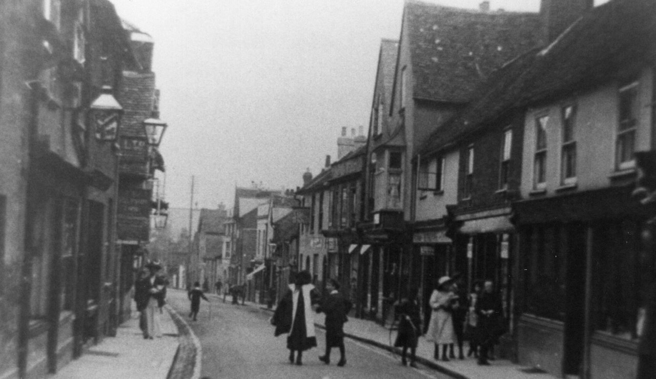
Back in Guildford for the mystery vintage picture this week and a picture postcard view from the early 1900s. Do you recognise this street?
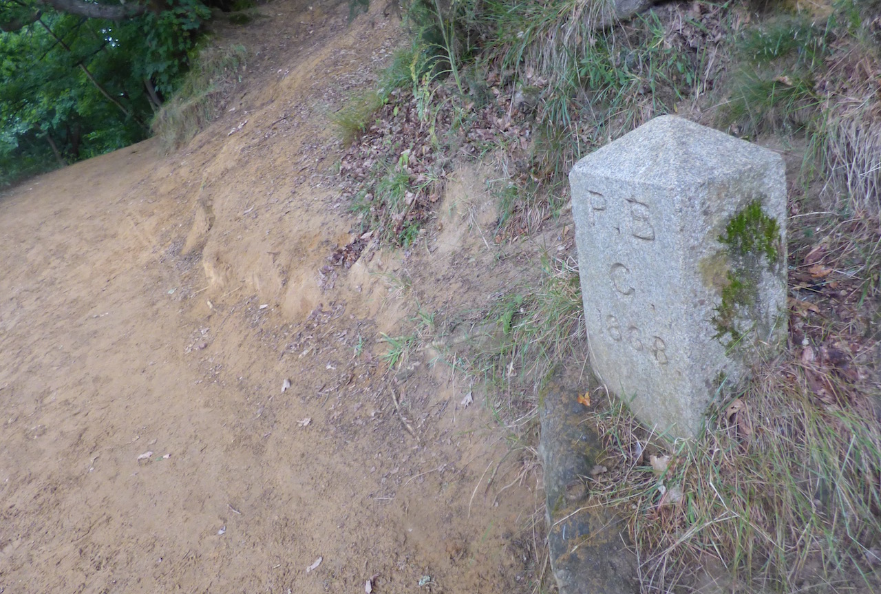
A Guildford Borough boundary stone in a sandy location, but where?
The quirky picture shows one of many Guildford Borough boundary stones that can be found. So, where is this one?
If you think you know the answers and can add some extra details, please leave a reply in the box below.
The answers, along with the next pair of images, will be published at about the same time next week.
Share This Post


Responses to Where Is This? No.268
Leave a Comment Please see our comments policy. All comments are moderated and may take time to appear. Full names, or at least initial and surname, must be given.

I'm living well for nothing at all! (See: No Trifling Matter: Magpie Trapped in Godalming Sainsbury’s)


Next stop, Debt Chasm! (See: We Should All Be Outraged About the Failure to Deal with Legacy Debt)


Jan Messinger
July 15, 2017 at 7:14 am
Really looks like Chertsey street to me.
Bernard Parke
July 15, 2017 at 7:23 am
1) Chertsey Street.
2) Green Lane.
John Lomas
July 15, 2017 at 4:15 pm
The old photo is Chertsey Street photgraphed from around the junction with North Street.
The nearest of thee buildings, on the right, with the gable end still has it’s first floor bay window and is now The Beauty Spot.
Mike Williams
July 15, 2017 at 5:41 pm
At last two slightly easier pictures I hope : Chertsey Street without a bus in sight, and at St Catherine’s, where I stained a pair of white shorts sliding down the very yellow sand. Even Daz couldn’t get it out.
Dave Middleton
July 16, 2017 at 10:55 am
The street scene is Chertsey Street at Guildford. Most of the buildings on the right of the street are still there, including the Spread Eagle, renamed some years ago as the Guildford Tup for some baffling reason.
Incidentally, in Epsom where I was raised we also had a Spread Eagle in the town centre, locally known as “The Flat Duck”.
On the left in the foreground is the Dolphin public house, long ago demolished.
I think the boundary stone is by the river near the footbridge below St Catherine’s and Ferry Lane.
John Thorp
July 19, 2017 at 10:03 am
The vintage picture is of Chertsey Street looking down from the junction with North Street.
It is remarkable that many of the buildings on the right remain today when so many elsewhere in the town have been swept away.
My abiding memory is of Messinger’s ironmongery and tool shop, an amazing emporium where it was most unusual that they did not have what you needed.
Although the shop was refitted a couple of times I can remember it with the narrow entrance and the dark interior.
It had a long counter with narrow alleys behind flanked by tall racks and shelving from which the staff would produce whatever you asked for.
It was quite a shock when the first refit opened up the space. The staff had a wealth of knowledge and were so patient with their customers.
I remember each autumn making several visits to their firework counter, planning which ones to buy for our display at home.
Chriis Townsend
July 20, 2017 at 5:44 pm
The vintage picture shows Chertsey Street, viewed from the south.
The lamp and sign shown to its left belong to the Dolphin Inn. The lady in the stylish hat stands beside the passageway and yard through to North Street. The old inn was demolished about 1916, after some controversy.
In the centre, the building with the hanging sign was the Leopard beerhouse, now Dylan’s barber’s. Further down the street, the light-coloured building with the cart outside was another beerhouse, the Spread Eagle; the Guildford Tup occupies the same building and an extension into the shop to its right.
I recall the shop on the far right as Messinger’s tool shop (but now Cath Kidston); it was a good place to choose fireworks for Bonfire Night.
The shop with the bay window upstairs (now The Beauty Spot) was for many years Taplin’s pork butchers who sold such delicacies as brawn (yum!) and pigs’ trotters.
The boundary stone is beside the river, below St Catherine’s Hill, where we used to play in the sand as children; I doubt sliding down the bank is allowed today: “Health and Safety”.
“P B” doesn’t stand for parish boundary, but parliamentary boundary, as shown on old maps.
Albert Robinson
July 21, 2017 at 3:17 pm
It looks for all the world like Chertsey Street near to the junction with North Street.
Bill and Doug Stanniforth
July 21, 2017 at 4:50 pm
1. Chertsey Street
2.The boundary is at St Katherine’s, famous for being used as a film location for “The Black Tent” also very close to the home of Guildford’s second most well known journalist.
[Ed St Katherine’s with a K, surely not? And who is the most well know journalist them?]
Brian Holt
July 21, 2017 at 8:40 pm
1. Looking down Chertsey Street towards Martyr Road.
The Boundary Stone is beside the river at St Catherine’s, near the stream at the bottom of Ferry Lane.