- Stay Connected

Socialize

 Abraham Lincoln
If given the truth, the people can be depended upon to meet any national crisis...
Abraham Lincoln
If given the truth, the people can be depended upon to meet any national crisis...

 Guildford news...
for Guildford people, brought to you by Guildford reporters - Guildford's own news service
Guildford news...
for Guildford people, brought to you by Guildford reporters - Guildford's own news service
Where is This? No.273
Published on: 26 Aug, 2017
Updated on: 26 Aug, 2017
By David Rose
Bit late with this the latest Where Is This? I’ve been away on a boating holiday on the Norfolk Broads and very good it was too. Didn’t see any speedboats though!
The answers to the previous mysteries were correctly identified by a number of readers, while some of the replies were not quite right.
The vintage picture of the ‘Rustic Bridge’ was the previous one that spanned the River Wey close to Shalford Road and Guildford Rowing Club’s boathouse.
The fountain can be found at the Stag Hill Campus at the University of Surrey.
Click here to see the previous post and all the replies.
This week’s vintage picture comes from a collection of photos that once belonged to a family and ended up for sale in a Guildford charity shop.
Ben Darnton of Guildford’s Collectors Record Shop and his Facebook page Guildford Past & Present snapped them up. I have now bought this fascinating collection from him. They include lots of family photos, old postcard views and other vintage pictures in and around Guildford.
Who they once belonged to is a bit of a mystery, but some clues in the collection and a search on the genealogy website Ancestry UK reveals that they are connected to an Emily Cumber who married a George Fordham.
She lived in Shalford and after she married George they lived in Guildford and had three children.
I will be writing an article showing more of these photos soon, but if anyone knowns anything of these families and can add some details, please email me at drosedragon@gmail.com.
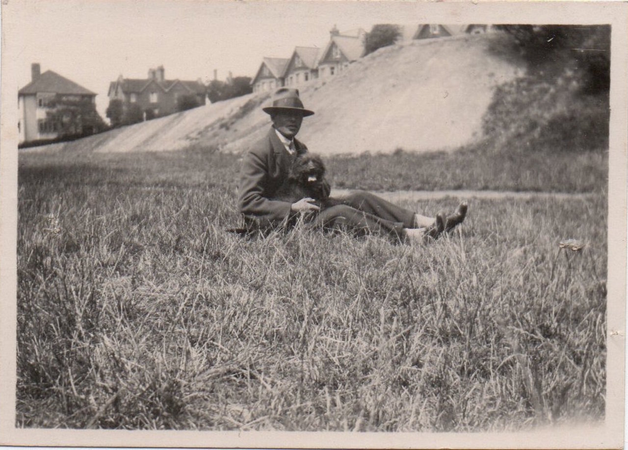
Do you recognise where this is? It’s not far from Guildford town centre. Click to enlarge pictures in a new window.
This picture possibly features George Fordham. Do you know the location? I think I know, but answers from readers would be appreciated.
The Stanniforth brothers in their latest reply were trying to guess the location of the fountain based on locations of other quirky pictures recently featured.
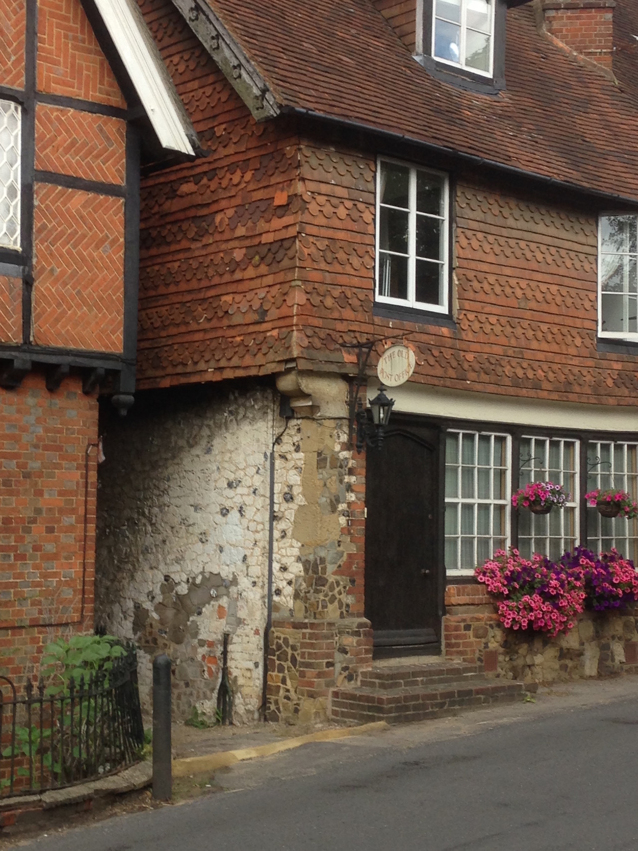
Where is the “Old Post Office’?
Going on that, this week’s shows ‘The Old Post Office’ in a village from which I featured something else not too many weeks ago. So, there is a clue.
Do you know the location?
All being well, the answers, along with the next pair of images, will be published in about a week’s time.
Share This Post


Responses to Where is This? No.273
Leave a Comment Please see our comments policy. All comments are moderated and may take time to appear. Full names, or at least initial and surname, must be given.

I'm living well for nothing at all! (See: No Trifling Matter: Magpie Trapped in Godalming Sainsbury’s)


Next stop, Debt Chasm! (See: We Should All Be Outraged About the Failure to Deal with Legacy Debt)


A Tatlow
August 27, 2017 at 1:52 pm
Well I know the second photo is of Albury, but then I live in the village. I’ll be interested to know the location of the other one.
Margaret Drake
August 27, 2017 at 6:59 pm
I think is the Foxenden Quarry in York Road, locally known as The Pitt in the 1950s.
John Lomas
August 28, 2017 at 10:21 am
The Old Post Office is on The Street in Albury.
Chris Townsend
August 31, 2017 at 3:15 pm
The old photo is of Foxenden Quarry on York Road, with the house named “The Quarry” on the left, and the row on the right between Falcon Road and Stoke Road.
Charles Hoskins Master, who built and developed the Friary Brewery, defrayed the cost of the old chalk quarry when it was bought for the town as a recreation ground in 1914.
“The Old Post Office” is one of the buildings with the ornate chimneys on Albury Street.
Aubrey Lehay
August 31, 2017 at 6:53 pm
Racks Close.
Doug and Bill Stanniforth
September 4, 2017 at 11:44 am
We think it’s Foxenden Quarry with York Road in the background.
The old Post Office is in Albury.
Brian Holt
September 6, 2017 at 7:48 pm
1. I think it may be the slope of the Mount looking towards Mountside or Mareschal Road.
2. The old Post Office was in The Street, Albury. Going past the Drummond Arms towards Shere it was on the left towards that end of the village, where the tall chimney pots are on buildings.
Noreen Adams
September 9, 2017 at 6:45 pm
Shops at Fairlands Estate.
Norman Hamshere
September 10, 2017 at 8:58 am
One small fact not mentioned, even by Chris Townsend! Cut into this bank by 1940 was the air-raid shelter used by the infants from Sandfield school.
When the siren sounded we assembled in the playground with our gasmasks and then ran up York Road to the pit.
However, due to irate parents worried that we could have been shot up during this evacuation we later remained in school but sat on the floor under our desks – not nearly so much fun!
I do not know when it was dismantled but it was a grassy bank again by 1948 when I delivered newspapers along York Road.