- Stay Connected

Socialize

 Abraham Lincoln
If given the truth, the people can be depended upon to meet any national crisis...
Abraham Lincoln
If given the truth, the people can be depended upon to meet any national crisis...

 Guildford news...
for Guildford people, brought to you by Guildford reporters - Guildford's own news service
Guildford news...
for Guildford people, brought to you by Guildford reporters - Guildford's own news service
Where Is This? No.294
Published on: 2 Sep, 2018
Updated on: 3 Sep, 2018
By David Rose
Many of the replies to the previous mysteries were correct.
The vintage picture featured the Black Horse pub in Gomshall, now a tea and gift shop called the Lavender Goose.
The quirky picture was of All Souls Church in Sutton Green. John Lomas correctly noted that it was built as a war memorial to the men of the village who died on active service during the First World War. That’s the connection to the silent soldier silhouette that currently stands in front of it.
Lots of additional details in your replies about the Black Horse, its brewery that was once there and various owners and usage. To read them click here for the previous post.
Where is this in Guildford town centre? Click on pictures to enlarge in a new window.
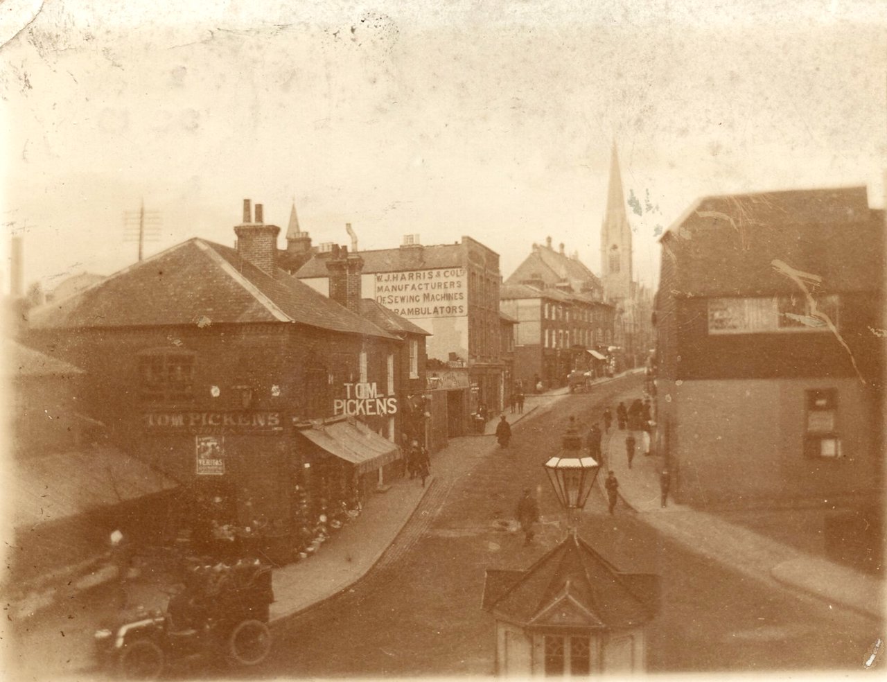
Back to Guildford town centre this time for the vintage picture, and a rather splendid view copied from a photo in Michael Williams’ family collection. His family being Williams’ Bros newsagents.
He is not sure why the photo was taken, but he said his family lived in the building from where the picture was taken. It looks to date to circa 1910.
Although it is in the form of a postcard with the normal postcard details printed on the back, I do not think it was a published postcard for public use as such. More likely copies were printed but used as personal stationery by the Williams family.
So, what is the view of and what details can be seen?
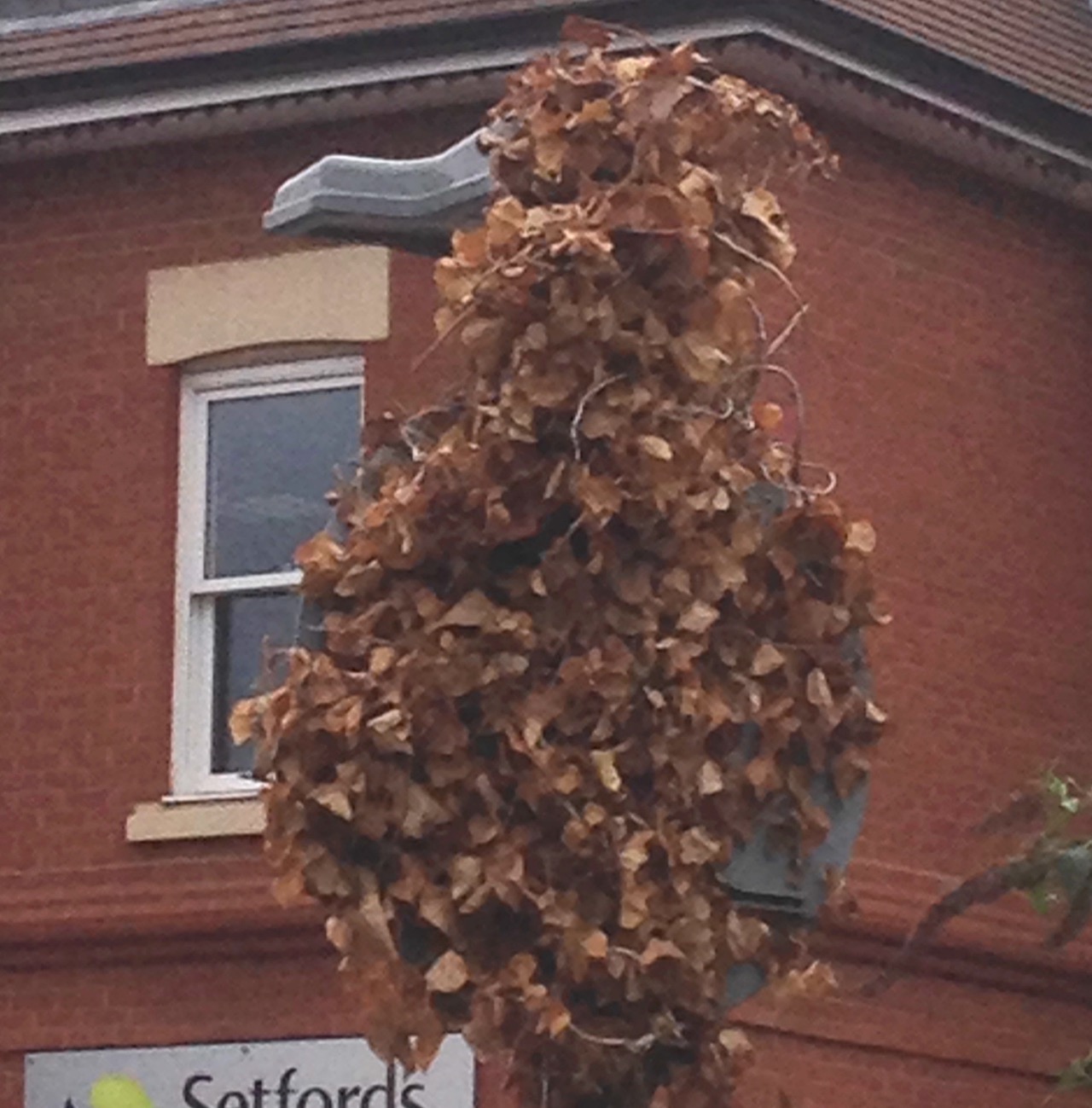
Is it a bird or is it a road sign, and where?
The quirky picture is actually a road sign covered with ivy and with its illuminating lamp on top – although the ivy looks to be dead. From the angle I took the photo, it perhaps resembles a bird? You may have other suggestions.
But where can it be found? It’s in Guildford town centre.
If you know the answers and perhaps can add some more details, please leave a reply in the box below. I’ll give the answers in about a couple of weeks’ time with the next images.
And please remember to include your full name in the reply box.
Share This Post


Responses to Where Is This? No.294
Leave a Comment Please see our comments policy. All comments are moderated and may take time to appear. Full names, or at least initial and surname, must be given.

I'm living well for nothing at all! (See: No Trifling Matter: Magpie Trapped in Godalming Sainsbury’s)


Next stop, Debt Chasm! (See: We Should All Be Outraged About the Failure to Deal with Legacy Debt)


John Lomas
September 3, 2018 at 8:44 am
The quirky picture is on Jenner Road just above the Sydenham Road exit.
The sign is supposed to indicate that Jenner Road is one-way uphill; from that point; is it a sign of local authority inefficiency that on Streetview the signs, on either side of the road, do not appear to be facing the oncoming traffic in order to get their message across. Does the dead ivy also cover up the sign?
The old picture shows North Street taken from one of the two premises immediately south of the entrance to Friary Court (previously the Royal Surrey Militia depot).
The Methodist chapel is prominent at the top of the view
My mother used to have a Harris treadle sewing machine, in a cabinet, which would have been purchased new in about 1938, she considered it superior to the ubiquitous Singer.
I will research the motor car further and hope to come back with a another entry ID’ing it later.
I have to admit to not knowing that they were a Guildford manufacturer.
Ian Kelly
September 3, 2018 at 3:17 pm
On Jenner Road, outside Setfords maybe?
Charles Graham
September 3, 2018 at 4:01 pm
Bottom of North Street? The spire seems to be the old Methodist church on the corner of Woodbridge Road so the shop on the left in the pcture must be on the frontage to the Friary.
Chris Townsend
September 9, 2018 at 7:23 am
The vintage scene shows the foot of North Street, where it bends round into Onslow Street to the left, and Friary Street to the right.
That’s the Wesleyan Methodist Church on the corner of Woodbridge Road. Harris’s pram shop was there until at least the 1950s, when I coveted the rocking horse in the window; the shop was later Mothercare.
Next door, higher up the street was Bon Marche, a children’s wear shop, with a doll in the window beautifully dressed – another object of desire and a distraction when my mother simply wanted to reach Hall’s Stores, the grocer’s on the corner of Commercial Road where we were registered for some of our rations. The van would deliver after one placed one’s order.
Tom Picken’s emporium was well before my time; it sold everything under the sun, including Veritas gas mantles, as in the advert on the wall. Does that sign suggest that the photo is a little later than 1910?
Was Shirley’s outfitters – a good place for workwear – later on the same site?
The building in the foreground was presumably associated with the weighbridge which existed then; was it used in connection with the cattle market at the top of the street, or by businesses at the nearby wharf off Friary Street?
Set back, on the left of the photo, was where Williams Bros newsagents was located. I’m intrigued to know where the family lived; was it in part of the former Militia Barracks, perhaps in the home of the later Alby John School of Dancing?
The quirky road sign is on Jenner Road.
Mike Williams
October 8, 2018 at 3:15 pm
For Chris Townsend.
Actually David misheard me. The Williams family didn’t live there. Ten out ten for remembering our newsagents though.
Surprising too that one or two mentioned Alby and Rene John’s dancing school, but not Buyers.
Shirleys was there later. As was Pickfords, Edward Jones Chemist (later Moss) and Lasletts rings a bell?
Dave Chillistone
September 11, 2018 at 11:49 pm
The scene in Where is this? No 294 is looking up North Street.
The roadway going off to the left looks like it’s Onslow Street so the roadway going off to the right would be Millbrook? The scene might be a few years before 1910 because there is only one car in the picture.
The car dates from the early 1900s by the look of it. By 1910, this being the county town, there would have been several cars in such a street-scene, and the more up-to-date cars would have had roofs, albeit open-sided and held up with stays at the front.
According to a very old lady I knew who lived in Guildford Park Road in the mid-1960s, Picken’s sold anything and everything, and if they hadn’t got what you wanted they’d order it in specially.
In the distance you can see the prominent spire of the Methodist Church, demolished in the 1970s. In the 1960s there was a coffee bar running in the church on Saturday evenings, sometimes with live music. I’ve been trying to work out when it was demolished by referencing it to the Guildford pub bombings in 1974. I’m fairly sure the church was demolished some time before the incidents at the Seven Stars and the Horse and Groom.
I can’t place the oddity picture as it’s a modern picture and I haven’t been back to Guildford for around 25 years!
Bill Staniforth
October 5, 2018 at 3:51 pm
Picture 1 is the bottom of North Street, taken from the bridge covering the path through to the bus station and also housing the Alby John School of Dancing.
We don’t remember Tom Picken’s Store but wondered if he was related to Slim?
Picture 2 is a No Entry sign at the end of Sydenham Road where it meets Jenner Road.
We can’t remember if we answered this one as it seems to have been hanging around for months.
[Ed: No you haven’t. We’ve been a bit slow in getting the next set of pictures together].
Aubrey Leahy
July 12, 2019 at 8:51 pm
Was it perhaps taken from a window in the Militia barracks, just above the spot where, for many years, evening paper seller Mick Guddicci(?) would holler out, “StandardNewsStaarrrrrr!”?