 Abraham Lincoln
If given the truth, the people can be depended upon to meet any national crisis...
 Guildford news...
for Guildford people, brought to you by Guildford reporters - Guildford's own news service
Where Is This? No.5
Published on: 20 Apr, 2012
Updated on: 22 Apr, 2012
by David Rose
Only one reply to last week’s poser, and Bernard Parke, who is usually pretty good at identifying the locations, was unfortunately off target.
The first photo showed a view taken in Worplesdon in the 1900s looking up towards Perry Hill featuring its United Reformed Church and adjacent cottages along what is today the A322. Further down the road (behind the photographer) is Rickford Mill and Rickford bakery.
The second photo showed the Chapel of the Good Shepherd that was in Foxburrows Avenue, Westborough.
The origins of a chapel on this site go back to when the first houses at Westborough were built in the 1920s. Originally it was administered by St Nicolas parish. When, in 1947, the Anglican conventional district of Westborough came into being, it is likely that it took control of the chapel with clergy coming from St Francis’ Church in Beckingham Road (dedicated in 1933).
Westborough became a parish in its own right in 1958, and the photo shown in the previous post dates to about that time when the chapel was extended to improve its worship area.
In 1965, St Clare’s Church-cum-hall was opened at Southway in Park Barn, and services of worship ceased at the Chapel of the Good Shepherd. However, the building continued to be used and hired out for social events until the land it stood on was sold in the early 1980s to raise funds for an extension to Sr Clare’s Church. Houses now occupy the site.
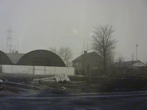
Now this week’s photos. The one above shows a vacant plot of land with some pylons in the background and floodlights from the old Guildford City football ground. Any ideas which road is seen here?
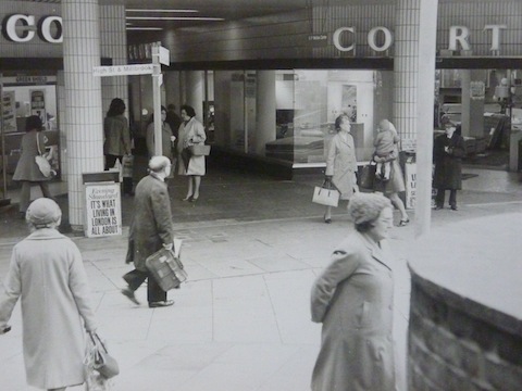
Below: Busy shoppers pass in front of Courts. Where was that store?
If you think you know the answers, leave a reply in the box below. All replies will be posted at the same time in about a week’s time, along with a new post with the answers to this week’s photos, and the next pair of images.
Responses to Where Is This? No.5
Recent Articles
- Dragon Review – Sherlock Holmes: The Hunt for Moriarty – Yvonne Arnnaud Theatre
- Delays to Report on Housing Revenue Account Scandal Criticised by Scrutiny Committee
- Notice: German Mini Christmas Market – November 30
- Police Smashed Roofing Scam After Rogue Workers Got Away With Thousands
- Story of ‘Jessie’s Seat’ Topiary Railway Memorial to a Guard Killed at this Spot near Chilworth
- Birdwatcher’s Diary No. 339
- Tongham and Normandy Are Both Facing a Possible Housing Boom
- Dragon Review: Buddy – The Buddy Holly Story – Yvonne Arnaud Theatre
- Good Design Rewarded – Co-Living Development Scoops Overall Winner Prize
- Challengers Get Set To Launch Their Big Christmas Campaign


Recent Comments
- roger kendall on Birdwatcher’s Diary No. 339
- Robert Jennings on Memories Of Queen Elizabeth Barracks And The Women’s Royal Army Corps
- Julie Howarth on Biddles – A Guildford Business for 140 Years Today
- RWL Davies on No Promise of A Mayor for Surrey
- John S Green on ‘Disaster in the Making’: Residents React with Anger and Distrust
- Amari Hawthorne-Bailey on Memories Of Queen Elizabeth Barracks And The Women’s Royal Army Corps
Search in Site
Media Gallery
Cllr Townsend on Waverley’s CIL Issue
August 27, 2025 / Comments Off on Cllr Townsend on Waverley’s CIL Issue / Read MoreMP Zöe Franklin Reviews Topical Issues
August 27, 2025 / Comments Off on MP Zöe Franklin Reviews Topical Issues / Read MoreMP Hopes Thames Water Fine Will Be ‘Final Nail in Its Coffin’
August 27, 2025 / Comments Off on MP Hopes Thames Water Fine Will Be ‘Final Nail in Its Coffin’ / Read MoreNew Guildford Mayor Howard Smith
August 27, 2025 / Comments Off on New Guildford Mayor Howard Smith / Read MoreA New Scene for a Guildford Street
August 27, 2025 / Comments Off on A New Scene for a Guildford Street / Read MoreDragon Interview: Sir Jeremy Hunt MP on His Knighthood and Some Local Issues
August 27, 2025 / Comments Off on Dragon Interview: Sir Jeremy Hunt MP on His Knighthood and Some Local Issues / Read MoreDragon Interview: Paul Follows Admits He Should Not Have Used the Word ‘Skewed’
August 27, 2025 / Comments Off on Dragon Interview: Paul Follows Admits He Should Not Have Used the Word ‘Skewed’ / Read MoreDragon Interview: Will Forster MP On His Recent Visit to Ukraine
August 27, 2025 / No Comment / Read MoreDragon Interview: Fiona Davidson on the ‘Devolution’ Proposals for Surrey
August 27, 2025 / No Comment / Read More


Bernard Parke
April 21, 2012 at 6:34 am
1) I believe this to be taken on the A3 near the Joseph Road blocked off junction.
It could be the site on which REFFELLS ENGINEERING once traded
2)Courts outlet was situated at the end of Friary Street.
They got very annoyed when The Borough built the structure outside their window often used for a site for a children roundabout.
The reason was it obscured their view from people coming down North street.
Courts Head Office was situated in South London and at one time were my customers to whom I arranged for them to accept credit cards and Electronic Funds Transfer
Caroline Reeves
April 21, 2012 at 7:56 pm
Courts was either side of Friary Passge, where TKMax and New Look are now.
I’m not sure about the first one, could be Joseph’s or Stocton Road.
Carol Norris
April 22, 2012 at 10:31 am
Photo 2 : Towards bottom end of Guildford High Street – on the left going down.
Joyce Kirkpatrick
April 22, 2012 at 10:11 pm
Doesn’t look much different today!
Its Friary Street /bottom of North Street .
Bought our three piece suite from there a mixed striped monstrosity circa 1976…
Now a women’s retail store.
Ian Plowman
April 25, 2012 at 8:49 pm
Photo 1 Joseph road
Photo 2 – Friary Street – Courts is now New Look and the CO to the left was Tesco – now TK Max
Regards
Ian
Darol Radley
April 25, 2012 at 10:29 pm
Courts was located at the bottom of North street where New Look is located now.
I had forgotten, however, that Tesco was located where Woolworth used to be before TKMax.
This must put the date of the picture in the mid to late eighties.
Could the road be Walnut tree Close?