 Abraham Lincoln
If given the truth, the people can be depended upon to meet any national crisis...
 Guildford news...
for Guildford people, brought to you by Guildford reporters - Guildford's own news service
Where Is This? No:25
Published on: 18 Sep, 2012
Updated on: 18 Sep, 2012

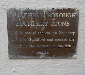
The plaque above the boundary stone within a wall in Haydon Place explaining what the stone is. The stone itself is inscribed ‘1762’ and was last week’s mystery date picture.
By David Rose
Jackson’s Garage, the mystery photo featured last week, was at 97 High Street. The site is now where Millbrook / A281 sweeps through the town on past Debenhams towards Shalford.
Many of your were correct with your replies, click here to see last week’s page and the replies at the foot of it.
However, I think Dave Peters’ reply, in which he believed the location was the top of the Upper High Street, was where motor dealers E.J. Baker once was. And Puttocks was on the other side of that part of the Upper High Street. I stand to be corrected by those with longer memories than me!
The mystery date was a bit trickier, but Chris Townsend correctly identified it as being on the boundary stone on the east side of Haydon Place, near the junction with North Street, once the Surrey Arms, but more recently Pizza Hut. There is a plaque above it that tells the reader what it is. See picture.
Here we go with this week’s pair…
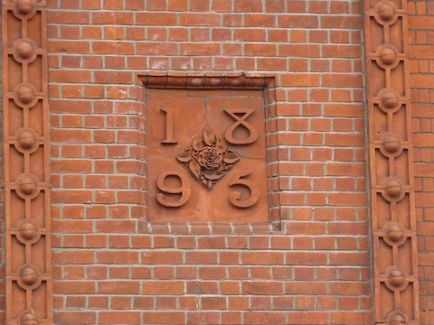
The mystery date is set within a nice piece of terracotta among brickwork on a building somewhere in Guildford town centre. Do you recognise it?

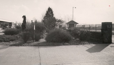
Recognise this? You will probably have know it after the garden area was built on. The bus shelter (right) and the building on the far left might be a give away.
The mystery photo actually dates to the 1930s. If you need some clues, look to the far left – recognise that building? And the bus shelter and railings? They were all there up to about 25 years ago. The area that is planted up in the middle was later built on – single storey buildings related to the building on the left.
If you know the answers and can supply more details, please leave a reply in the box below. All replies will be posted at about the same time next week, along with a new post with the answers to this week’s photo and mystery date, and the next pair of images.
Responses to Where Is This? No:25

Click on cartoon for Dragon story: Public Asked for Views on SCC’s Proposal for Reduced Speed Limits


Recent Articles
- Notice: Can You Help the University of Surrey Research Elderly Falls?
- Opinion: Waverley Has Failed Spectacularly on CIL
- Highways Bulletin: Smarter Planning for Better Bus Journeys in Surrey
- Letter: Will GBC’s New Planning Document on Building Heights Be Effective?
- Proposed New Leisure Contract Should Improve Facilities and the Council’s Income
- Witness Appeal Following Fatal Collision
- Celebration at Guildford Cathedral of Its Latest and Future Church Leaders
- Photo Feature: Now You See It…
- Letter: Snail-paced Progress for Full Weir Repair
- Mayor’s Diary: July 5 -July 20


Recent Comments
- Jan Messinger on Public Asked for Views on SCC’s Proposal for Reduced Speed Limits
- Fiona White on GBC Asks Residents for Views on Its Draft Building Height Guidance
- Dave Middleton on Letter: Fine Those Guilty of Anti Social Behaviour
- Carina Coverly on GBC Asks Residents for Views on Its Draft Building Height Guidance
- M Durant on Online Event Will ‘Help Residents Have Their Say On Local Government Reorganisation’
- Jim Allen on GBC Working Hard To Mitigate Looming Weyside Urban Village Deficit
Search in Site
Media Gallery
Dragon Interview: Local Artist Leaves Her Mark At One of England’s Most Historic Buildings
January 21, 2023 / No Comment / Read MoreDragon Interview: Lib Dem Planning Chair: ‘Current Policy Doesn’t Work for Local People’
January 19, 2023 / No Comment / Read MoreA3 Tunnel in Guildford ‘Necessary’ for New Homes, Says Guildford’s MP
January 10, 2023 / No Comment / Read More‘Madness’ for London Road Scheme to Go Ahead Against ‘Huge Opposition’, Says SCC Leader
January 6, 2023 / No Comment / Read MoreCouncillor’s Son Starts Campaign for More Consultation on North Street Plan
December 30, 2022 / No Comment / Read MoreCounty Council Climbs Down Over London Road Works – Further ‘Engagement’ Period Announced
December 14, 2022 / No Comment / Read MoreDragon Interview: GBC Reaction to the Government’s Expected Decision to Relax Housing Targets
December 7, 2022 / No Comment / Read MoreHow Can Our Town Centre Businesses Recover? Watch the Shop Front Debate
May 18, 2020 / No Comment / Read More


Brian Holt
September 20, 2012 at 10:59 pm
The picture is the old Co-op milk dairy in Woodbridge Road now Curry’s/PC World, Ladymead.
Doug Staniforth
September 21, 2012 at 3:05 pm
I think the building on the left is the old (Coop) dairy on Ladymead where Currys now is.
Ray Springer
September 21, 2012 at 8:28 pm
The picture with date 1895 is of a brick panel above French Connection in North Street on the corner of Market Street.
This building was a Berni Inn restaurant some years back, and before that the Gammons department store
Chris Townsend
September 22, 2012 at 7:01 am
The date is on the former Gammon’s store, at the top corner of North Street and Market Street.
The photo is of the Co-op Dairy, Woodbridge Road.