 Abraham Lincoln
If given the truth, the people can be depended upon to meet any national crisis...
 Guildford news...
for Guildford people, brought to you by Guildford reporters - Guildford's own news service
Opinion: Why Are Five-storey Blocks Allowed in An Area of Outstanding Natural Beauty?
Published on: 31 Dec, 2024
Updated on: 5 Jan, 2025
Local resident, John Harrison, a member of the St Catherine’s Village Association, was one of two objectors allowed to address GBC’s Planning Committee on the proposal to redevelop the former University of Law site in St Catherine’s, Guildford. Here he gives his personal view on the way the planning committee makes important decisions and offers a guide to planning jargon…
By John Harrison
Many people are wondering why Guildford Borough Council granted planning permission for 131 flats in five-storey blocks, situated in the green belt and what we have been used to calling an Area of Outstanding Natural Beauty (AONB*, now “National Landscape”) between Guildford and Godalming. There is much criticism of the officers and councillors, the latter particularly appearing out of their depth.

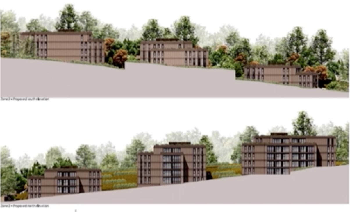
The five-storey buildings in a more elevated area of the site as presented to the Planning Committee. Image GBC
The LDRS story, published here in The Dragon, Benefits of Assisted Living Scheme Outweigh Harm to Designated Landscape GBC Planners Decide, uses the developer’s favourite PR photo, taken from an angle that deliberately hides the impact of the five-storey buildings where 79 per cent of the flats will be built, rather than giving readers a more objective view. It’s the three massive rear buildings that are the cause of all the objections.
See also: Benefits of Assisted Living Scheme Outweigh Harm to Designated Landscape GBC Planners Decide
The experts advising on what’s acceptable in the protected countryside all said the development would cause harm**. The Surrey Hills AONB advisor says of the developer’s concessions (five per cent fewer flats and using flat, rather than pitched roofs) “my previously expressed serious NL/AONB landscape concerns remain.” In the writer’s view, the flat roofs make the development more urban and even less appropriate.
GBC’s own landscape consultant concludes, the proposals “remain at odds with the objective of conserving and enhancing the Surrey Hills National Landscape within which the whole site lies. This part of the site is being overdeveloped, particularly in terms of height and massing.”
 Natural England confirms the legal requirement to give “the highest status of protection” to the area. It emphasises that the new statutory obligation to enhance these areas is an active duty, not a passive one; the council must take all reasonable steps towards protecting the landscape whilst the new duty not only underlines the importance of avoiding harm, but seeks to go further.
And why was an “extraordinary” GBC Planning Committee meeting convened at short notice a week before Christmas? Many councillors are new, elected in May with no prior knowledge of Planning. Some were absent and most appeared to have only spent a couple of hours skimming the 150-page detailed summary of the 300 documents submitted.
This is not good enough. Their role is to understand the local context and challenge the officers, who may be new to the area and have to arbitrate between these expert submissions on harm and the developer’s pleadings.
If councillors just accept the officer’s recommendation, they are wasting their time, but they need the skills to scrutinise.
Informed, demanding councillors would stiffen the backbone of the officers in their negotiations with developers over the acceptable level of harm**. One has to question the judgement of officers with limited local knowledge and who have until recently worked for builders and developers.
Local residents approve the principle of redeveloping this brownfield*** site which technically is a little island inset in the green belt that surrounds it. But the poorly designed series of five-storey flats, on rising ground that will appear as nine storeys from Pewley Down, is far too big. The new development could and should have been limited to roughly the current building height, not, effectively, heights that are three times the original.

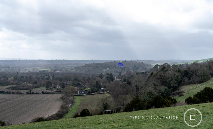
Images presented to the Planning Committee to allow visualisation of the view from near the north east corner of railings around St Catherine’s Chapel post proposed development at Braboeuf Manor, Portsmouth Road, and …
The way the harm to aspects of the site from surrounding viewpoints was presented to the committee made any proper and objective judgement impossible. The planned buildings are bigger and higher than those existing and will be plainly visible, damaging beautiful views.
A better way of demonstrating this is essential if Planning Committee members are to make proper evaluations. Once the buildings in this scheme are constructed, and the damage done, I suspect some committee members will regret their naivety and their decisions.

… from Pewley Down. Both images Elysian Residences/GBC. Zone 2, shown in the developer’s photograph with blue outline, will stick out like a sore thumb, thereby dominating the view and the Grade I listed St Catherine’s Chapel. If you find it difficult to count the number of storeys, spare a thought for the councillors.
Why did the officer not at least show the Pewley Down views in a legible way, as I requested at the meeting?
The developer has always said it expects to sell the Zone 3 land for flats so expect another application for something similar just to the right. The council should have refused consent, and insisted the three zones were well designed as one coherent scheme.
Instead, the committee was shown misleading wide-angle views, but most showed nothing, just views of scrub. Furthermore, the simple outline “see-through” proposals in the views convey little meaning to lay councillors.
GBC has for some time had a sophisticated computer program that models developments properly in 3-D, yet infuriatingly it refuses to use it or share the results. Why?
The Solum scheme by Guildford station has, as predicted, been seized upon by developers to build ever higher in the town centre; will they now invoke this latest error to build flats elsewhere in the countryside?
My glossary and guide to planning jargon
*Areas of Outstanding Natural Beauty (AONB) (now called National Landscapes (NL)) are high-quality landscapes selected for their natural beauty, including scenic views, relative wilderness, and tranquillity. There are strict planning controls and local authorities must give “great weight” to conserving these aspects. The recent name change adds the important duty for local authorities to enhance them as opposed to merely conserve them. The Surrey Hills National landscape covers 422 km², stretching from the Kent Downs AONB to the South Downs National Park, and was designated in 1958 and rebranded in 2023.
**Harm: Planners consider the potential harm that an inappropriate development might have. Different rules apply if it is merely significant rather than substantial harm. And there’s grading within this e.g. it might be at the upper end of significant or the lower end of substantial. These judgements are very carefully made by independent experts whose experience helps them assess and calibrate the effect. They are publicly funded and their role is to advise local authorities.
The green belt designation is primarily to prevent urban sprawl, and to maintain openness and separation between towns, eg Guildford & Woking and Guildford & Godalming.
Grey belt has yet to be properly defined. Urban economist’s submissions to the House of Lords committee currently examining the concept have suggested it should be those parts of the green belt within 800 metres of a commuter station. This would foster sustainable development and, they say, there is enough to accommodate nearly all the 1.5 million houses the government wants to get on and build.
Others think it should relate to the quality of the green belt: scruffy, neglected bits for example, maybe used for fly tipping; currently the quality is irrelevant for fear of encouraging speculators to trash the green belt in order to justify developing there. In my view, the location should be paramount with exceptions for things like parks in towns or the North Downs in Guildford.
***Brownfield is previously developed land. Common sense says this is a good starting point for new development, but it creates real anomalies. For example, a piece of flat land that was used as an airfield during the war – and where the landing strip continued to be used thereafter with a few associated hangers – is the logic for building nearly 2,000 houses at Wisley, despite poor public transport and inadequate day-to-day facilities. It also covers back gardens leading to ad hoc infill and neighbour conflict.
Public benefits are offset against the harm in a careful balancing act. They might include increased biodiversity (eg by adding some bat boxes, using drainage soak-aways to create a boggy corner for newts, or sphagnum moss on a flat roof), the opening up of a public footpath through the site or the widening of a pavement adjoining a site.
They often include one-off payments for things like health and education services. The problem is the money goes into a pot and may not be spent as it’s difficult to buy half a classroom or 10 per cent of a surgery.
An essential tariff is around £8,000 per flat to pay facilities for dog walkers, to encourage them not to walk their dogs on Surrey Heath between Guildford and Woking, due to the presence of a number of protected ground nesting birds. In practice, councils often use the money to catch up on years of lack of countryside parking maintenance. Were it not for the “dogs’ tax”, money like this could go towards social housing.
Too often, the benefits taken into account are not even public. They accrue to the shareholders in the development companies or the individuals who buy the flats that are built. These beneficiaries are very limited in number, in contrast to the population at large, whose landscape is harmed. In many peoples’ view, the benefits of the University of Law scheme do not justify the level of harm that will be caused.

Click on cartoon for Dragon story: Public Asked for Views on SCC’s Proposal for Reduced Speed Limits


Recent Articles
- Wildlife Group Invites Nature Lovers To Spot and Record Threatened Species
- Esme Campbell, Taking the Mantle of the Dragon’s Newest Reporter
- Witness Appeal Following Serious Assault in Guildford
- Notice: Can You Help the University of Surrey Research Elderly Falls?
- Opinion: Waverley Has Failed Spectacularly on CIL
- Highways Bulletin: Smarter Planning for Better Bus Journeys in Surrey
- Letter: Will GBC’s New Planning Document on Building Heights Be Effective?
- Proposed New Leisure Contract Should Improve Facilities and the Council’s Income
- Witness Appeal Following Fatal Collision
- Celebration at Guildford Cathedral of Its Latest and Future Church Leaders


Search in Site
Media Gallery
Dragon Interview: Local Artist Leaves Her Mark At One of England’s Most Historic Buildings
January 21, 2023 / No Comment / Read MoreDragon Interview: Lib Dem Planning Chair: ‘Current Policy Doesn’t Work for Local People’
January 19, 2023 / No Comment / Read MoreA3 Tunnel in Guildford ‘Necessary’ for New Homes, Says Guildford’s MP
January 10, 2023 / No Comment / Read More‘Madness’ for London Road Scheme to Go Ahead Against ‘Huge Opposition’, Says SCC Leader
January 6, 2023 / No Comment / Read MoreCouncillor’s Son Starts Campaign for More Consultation on North Street Plan
December 30, 2022 / No Comment / Read MoreCounty Council Climbs Down Over London Road Works – Further ‘Engagement’ Period Announced
December 14, 2022 / No Comment / Read MoreDragon Interview: GBC Reaction to the Government’s Expected Decision to Relax Housing Targets
December 7, 2022 / No Comment / Read MoreHow Can Our Town Centre Businesses Recover? Watch the Shop Front Debate
May 18, 2020 / No Comment / Read More


Recent Comments