 Abraham Lincoln
If given the truth, the people can be depended upon to meet any national crisis...
 Guildford news...
for Guildford people, brought to you by Guildford reporters - Guildford's own news service
Where Is This? No.193
Published on: 20 Jan, 2016
Updated on: 20 Jan, 2016
By David Rose
George Road, off Woodbridge Road, was correctly identified by a number of readers as being last week’s mystery vintage picture – and taken by Dave Salmon during the Queen’s silver jubilee in 1977.
Some readers even recognised the quirky picture as being the wine press in Bramley, near the library, and donated by its German twin town of Rhens am Rhein.
Click here to see last week’s post and the comments at the foot of it that contain extra details.
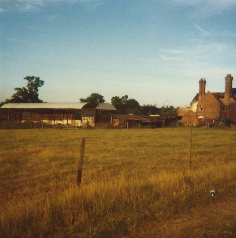
This week’s mystery vintage picture may well be a difficult one – some farm buildings.
It was emailed to me by David Seymour who grew up in Burpham Lane. This was a view from the end of his garden. I guess that’s a big clue.
Do you know which farm it was and what’s there now? This is the first picture I have seen of the farm and old pictures of Burpham are always rare anyway.
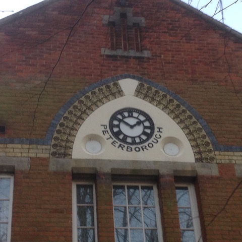
The quirky picture showing a clock may be a difficult one too – so I have included in the image part of the building on which it can be found, and a former military one at that.
That may be a dead give away. But why the word ‘PETERBOROUGH’? I have no idea, so I’d very much like to know.
Now, if the Stanniforth brothers can make a witty connection with these two pictures in relation to a prize should they get their answers right, they may be getting closer to that speedboat! Well, if a wealthy sponsor comes forward…
If you know the answers please leave a reply in the box below. Replies will be published at about the same time next week with two more mystery pictures for you to ponder.
Responses to Where Is This? No.193
Leave a Comment Cancel reply
Please see our comments policy. All comments are moderated and may take time to appear. Full names, or at least initial and surname, must be given.
Click on cartoon for Dragon story: Public Asked for Views on SCC’s Proposal for Reduced Speed Limits


Recent Articles
- Wildlife Group Invites Nature Lovers To Spot and Record Threatened Species
- Esme Campbell, Taking the Mantle of the Dragon’s Newest Reporter
- Witness Appeal Following Serious Assault in Guildford
- Notice: Can You Help the University of Surrey Research Elderly Falls?
- Opinion: Waverley Has Failed Spectacularly on CIL
- Highways Bulletin: Smarter Planning for Better Bus Journeys in Surrey
- Letter: Will GBC’s New Planning Document on Building Heights Be Effective?
- Proposed New Leisure Contract Should Improve Facilities and the Council’s Income
- Witness Appeal Following Fatal Collision
- Celebration at Guildford Cathedral of Its Latest and Future Church Leaders


Recent Comments
- George Potter on Letter: A Simple Footbridge Should Have Been Affordable to Keep Towpath Over Weir Open
- John Redpath on Proposed New Leisure Contract Should Improve Facilities and the Council’s Income
- Jan Messinger on Public Asked for Views on SCC’s Proposal for Reduced Speed Limits
- Fiona White on GBC Asks Residents for Views on Its Draft Building Height Guidance
- Dave Middleton on Letter: Fine Those Guilty of Anti Social Behaviour
- Carina Coverly on GBC Asks Residents for Views on Its Draft Building Height Guidance
Search in Site
Media Gallery
Dragon Interview: Local Artist Leaves Her Mark At One of England’s Most Historic Buildings
January 21, 2023 / No Comment / Read MoreDragon Interview: Lib Dem Planning Chair: ‘Current Policy Doesn’t Work for Local People’
January 19, 2023 / No Comment / Read MoreA3 Tunnel in Guildford ‘Necessary’ for New Homes, Says Guildford’s MP
January 10, 2023 / No Comment / Read More‘Madness’ for London Road Scheme to Go Ahead Against ‘Huge Opposition’, Says SCC Leader
January 6, 2023 / No Comment / Read MoreCouncillor’s Son Starts Campaign for More Consultation on North Street Plan
December 30, 2022 / No Comment / Read MoreCounty Council Climbs Down Over London Road Works – Further ‘Engagement’ Period Announced
December 14, 2022 / No Comment / Read MoreDragon Interview: GBC Reaction to the Government’s Expected Decision to Relax Housing Targets
December 7, 2022 / No Comment / Read MoreHow Can Our Town Centre Businesses Recover? Watch the Shop Front Debate
May 18, 2020 / No Comment / Read More


Teresa Bass
January 21, 2016 at 12:33 am
Burpham Court Farm!
And when the road went straight from Jacobs Well through to the Green Man junction of Burpham Lane.
Then the farm was still very much a dairy farm and the cows would be walked down the road twice a day to the milking sheds on the other side of the road.
The milking sheds were where the car wash and other buildings are located. Fab picture.
Bernard Parke
January 21, 2016 at 7:05 am
Stoughton Barracks.
John Lomas
January 21, 2016 at 9:51 am
I can only suppose that the old photo is Bower’s Farm which appears to now be under the Clay Lane/London Road roundabout, or the corner of Sainsbury’s store.
Some old maps seem to mark Burpham Lane as Jacobs Well Road. Was there an actual name change or did the two names co-exist with JW Rd running into BL?
The quirky picture is the main entrance at the centre of Queen Mary’s Mews on the Cardwell Keep site.
Some old pictures describe it as the mens’ quarters, (presumably to distinguish it from officers’ quarters), it was also known as the Peterborough Block.
Dave Middleton
January 21, 2016 at 2:21 pm
I’m going to take a wild guess at the farm buildings and say Winterhill Farm at Burpham, but I expect to be completely wrong!
The quirky picture is of the clock on the terrace of houses now known as Queen Mary’s Mews, within the Cardwells Keep development at Stoughton.
The houses were created by converting one of the single soldiers’ accommodation blocks (barrack blocks in old soldier speak), and this one was named Peterborough Block after the first Colonel of the Royal Surrey Regiment, Henry Mordaunt 2nd Earl of Peterborough, who raised the regiment and commanded its first parade on Putney Heath on 14th October 1661.
Pete Blow
January 21, 2016 at 5:34 pm
Presumably, the farm is where the Burpham Sainsbury’s now stands.
Incidentally, Burpham Sainsbury’s was their first branch to use barcode scanning. No need for the traditional price sticker gun.
John Lomas
January 22, 2016 at 7:06 am
Wiki reveals that: “The (Queen’s) regiment was raised in 1661 by Henry Mordaunt, 2nd Earl of Peterborough as The Earl of Peterborough’s Regiment of Foot on Putney Heath (then in Surrey) specifically to garrison the new English acquisition of Tangier, part of Catherine of Braganza’s dowry when she married King Charles II.”
We see there the Queen for whom it was founded and also the reason for Peterborough on the barrack block.
Brian Holt
January 25, 2016 at 5:52 pm
1. Is it Weylea farm that now has housing built on it?
2. This clock is on the second block of flats on the left in Cardwells Keep, at the old Stoughton Barrack site.
The word Peterborough around the clock refers to the name of the barrack block.
The Keep was converted into flats.
The officers’ mess, now know as King George’s Lodge was also converted into luxury flats.
The administration block, which housed the orderly room and officers with the quartermaster’s and RSM’s quarters at each end, is now known as Queen Elizabeth’s Mews.
Peterborough block renamed Queen Mary’s Mews has been converted into flats.
The other buildings were demolished.
ray springer
January 26, 2016 at 4:16 pm
The farm I think was Bower’s Farm and now the site of Sainsbury’s supermarket.
The quirky picture is a building in what was Stoughton Barracks and I reckon the Peterborough refers to the name of one section of the barracks.
Bill and Doug Staniforth
January 26, 2016 at 4:33 pm
The farm was probably where the A3 is now.
The clock is at Queen Mary’s Mews, Stoughton Barracks, formerly Peterborough Block (the officers’ mess).
Perhaps there was a Special (Speed) Boat Squadron at the barracks.
Chris Townsend
January 26, 2016 at 5:39 pm
The farm buildings belonged to Bower’s Farm, where Sainsbury’s is today. Some local street names are reminders of the farm.
The answer to the puzzle of the clock, at the site of the former Stoughton Barracks, is here:
http://www.queensroyalsurreys.org.uk/depots/depots05.shtml
“The majority of the Non-Commissioned Officers and Men serving at the Depot were single and were accommodated in the two blocks [shown in photos on the webpage]. The foremost of these is Peterborough block, named after the first Colonel of the [Queen’s] Regiment, Henry Mordaunt (Second) Earl of Peterborough, by whom it was raised and under whom it held its first parade on Putney Heath on 14th October 1661.”
Margaret Cole
January 27, 2016 at 12:05 pm
The Burpham picture I believe is the old Bower’s Farm which Sainsbury’s was built on.
No idea about the clock and Peterborough.
Andrew Backhurst
January 27, 2016 at 2:50 pm
I don’t remember the farm but it must be Bower’s Farm and the current site of Sainsbury’s in Burpham.