- Stay Connected

Socialize

 Abraham Lincoln
If given the truth, the people can be depended upon to meet any national crisis...
Abraham Lincoln
If given the truth, the people can be depended upon to meet any national crisis...

 Guildford news...
for Guildford people, brought to you by Guildford reporters - Guildford's own news service
Guildford news...
for Guildford people, brought to you by Guildford reporters - Guildford's own news service
Where Is This? No.287
Published on: 1 Apr, 2018
Updated on: 6 Apr, 2018
By David Rose
Many thanks to all who replied to the previous mystery pictures, all correct.
The vintage view showed Quarry Street in the early 1900s, and the plaque in the quirky picture commemorates the architect of Guildford Cathedral, Sir Edward Maufe, obviously at the cathedral.
Click here to see the previous post with lots of extra details by those who left a reply.
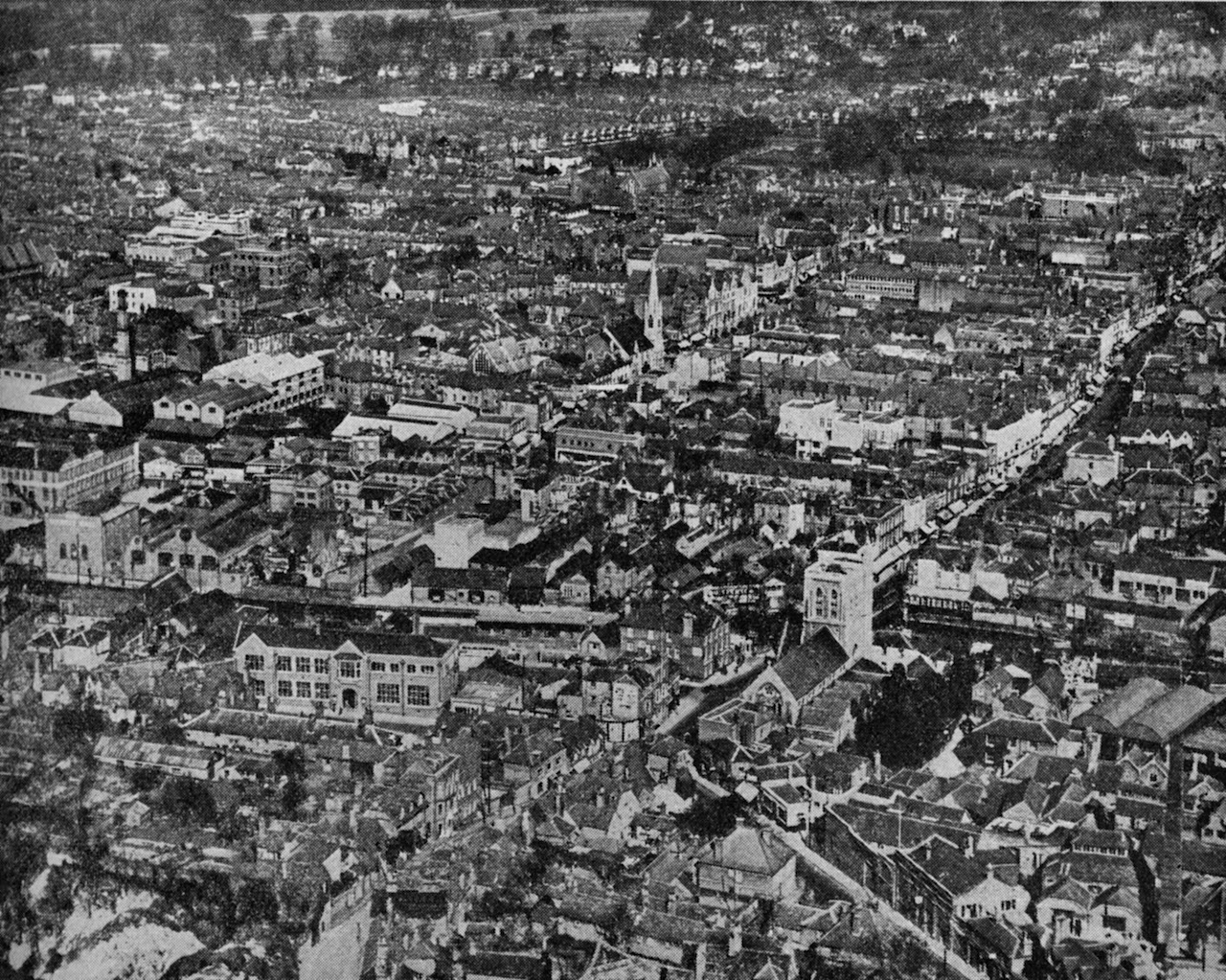
An aerial view of Guildford from the 1930s. What can you see? Click to enlarge in a new window.
The vintage picture this time is an aerial view that I guess was taken in about the 1930s. Lots of interest if you click on the image to enlarge it in a new window.
Can you identify the building that stands out rather well to the lower left-hand side and which is also to the left of St Nicolas Church, the church being a clue to give you some bearings?
Any details of other buildings that can be seen and which not longer exist would be welcomed.
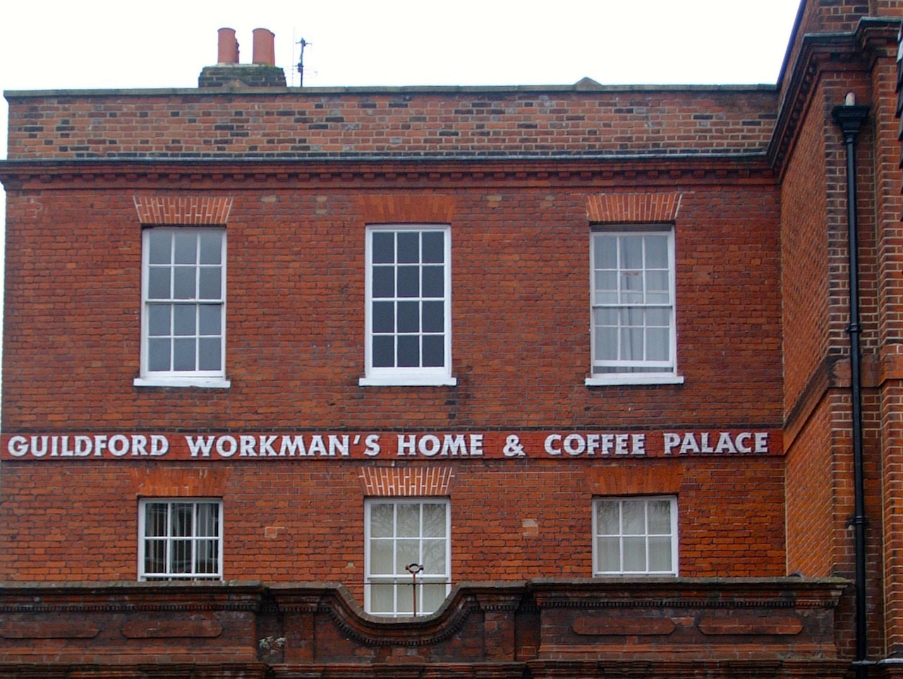
Do you know where this is?
The quirky picture was emailed by Aubrey Leahy. He wonders how many readers know where this is and what it is now?
If you know the answers and perhaps can add some more details, please leave a reply in the box below. I’ll give the answers in two week’s time with the next images.
And please remember to include your full name in the reply box.
Share This Post


Responses to Where Is This? No.287
Leave a Comment Please see our comments policy. All comments are moderated and may take time to appear. Full names, or at least initial and surname, must be given.

I'm living well for nothing at all! (See: No Trifling Matter: Magpie Trapped in Godalming Sainsbury’s)


Next stop, Debt Chasm! (See: We Should All Be Outraged About the Failure to Deal with Legacy Debt)


John Lomas
March 26, 2018 at 12:40 am
I think the one you are refering to is the large building on Park Street where I seem to remember having to go to in order to get my National Insurance number when I left school and started work.
But the one that fascinates me is the one next to the river and the Town Bridge at the junction with Farnham Road just to the left of the church tower.
I don’t recall ever seeing a building there.
An old map of 1871 identifies it as Guildford House and it is next door to the Nicholas Brewery.
Later maps just show it as a pub and even looking at The Lost Pubs Project I haven’t been able to put a name to it.
Just to the left of that and slightly higher, I believe we can see the Town Wharf and the shed where the treadwheel crane is.
The Workman’s Home etc is what an old map of 1974 names as a Church Army Men’s Welfare Hostel on Chertsey Street.
Bernard Parke
March 26, 2018 at 7:26 am
1) The old Technical School Park Street
2) Chertsey Street
Dave Middleton
March 26, 2018 at 11:27 am
The aerial view is super! So much change since then and so many buildings and businesses gone, not least the Congregational Church with the magnificent spire on North Street, where Burger King stands today.
If you look into the car park at the back of Burger King, you can still see a last vestige of the church in the form of an arch in the wall.
The large building, face on, to the left of St Nicolas Church was the Technical College, demolished in 1972.
The quirky picture is of the first and second floors of Vaughan House hostel on Chertsey Street, once upon a time a Church Army hostel, where Guildford character Private Chuck Sheffield of the Queen’s (Royal West Surrey) Regiment at Stoughton Barracks, lived his last few years after leaving the army with no less than 40 years service to his name.
[David Rose adds: I think you might be referring to the Methodist Church (magnificent spire) that was on the corner of North Street and Woodbridge Road, now the site of the Barclays Bank building. The vestige of the church you mention visible from Commercial Road I think was a Baptist Church. It too can be seen in the photo]
John Lomas
March 27, 2018 at 1:44 pm
Sending more time browsing this lovely old photo, I notice that the Royal Grammar School playing field and Allen House Bowling Green are visible right of centre near the top.
Mike Dillon
April 2, 2018 at 6:40 pm
The building to the left of St Nicolas Church was the Education Office.
I remember going there just as I was about to leave school for a meeting with Miss Elms who was the youth employment officer who had a list of all the companies willing to take on school leavers as
apprentices. How things have changed.
Slightly more to the left can be seen the electricity works and the Rodboro Buildings.
John Lomas
April 17, 2018 at 5:14 pm
I’m getting withdrawal symptoms, so have revisited this.
What are the barrel shaped roofs just above the Bury Street Almshouses?
Is that the Lion Hotel showing up as a large expanse of white on High Street opposite a building which is much taller than those around it?
Nobdy has mentioned the expanse of Stoke Park visible at the top center to left, the bend on Nightingale Road seems to be in view so the tennis courts and the barn are presumably hidden by the trees.