- Stay Connected

Socialize

 Abraham Lincoln
If given the truth, the people can be depended upon to meet any national crisis...
Abraham Lincoln
If given the truth, the people can be depended upon to meet any national crisis...

 Guildford news...
for Guildford people, brought to you by Guildford reporters - Guildford's own news service
Guildford news...
for Guildford people, brought to you by Guildford reporters - Guildford's own news service
The Surrey Hills National Landscape Boundary Set To Be Expanded
Published on: 25 Nov, 2025
Updated on: 25 Nov, 2025
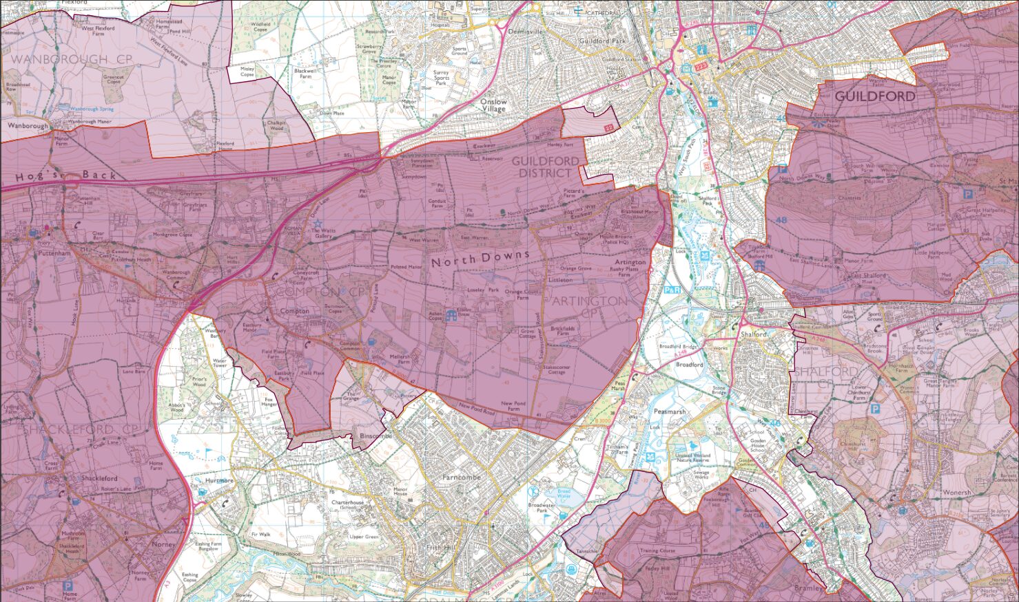
Surrey Hills proposed expansion areas near Guildford Natural England – click on image to enlarge
By Chris Caulfield
local democracy reporter
The Surrey Hills could be expanded for the first time since it was first designated as an area of outstanding natural beauty almost 70 years ago.
The Surrey Hills National Landscape boundary has remained the same since it was first introduced in 1958 but throughout that time there have been calls locally to reconsider increasing the beauty spot’s borders.

The Surrey Hills Landscape spans the entire width of Surrey.
Some of the land that lies next to the Surrey Hills is currently classed as Areas of Great Landscape Value by councils to recognise its value at a county level.
Now, Natural England is exploring whether to formally include 129 square kilometres of these areas into the Surrey Hills National Landscape following a series of consultations on the proposed extensions.
The first took place in 2023 with 1,518 people taking part, a second held in 2024 received over 375 responses. Natural England’s report read: “The evidence provided through the first consultation process presented strong arguments to include additional land in the Surrey Hills.
“Following the decision to add further land to the proposal a second round of consultation was required in accordance with our duties under the Countryside and Rights of Way Act 2000.
“The second consultation was launched with stakeholders invited to provide a response on the changes to our proposals, including further additions, minor deletions and new land in East Hampshire. We received over 375 responses to the second consultation, the vast majority of which were supportive of the proposals.”
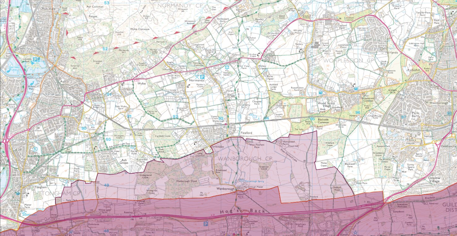
Surrey Hills proposed expansion areas to the north of the Hog’s Back near Guildford Natural England – click on image to enlarge
The final review period, which the public can take part in, runs until January 14, 2026. The prime purpose of the designation is to conserve and enhance the natural and scenic beauty although it understands that the Surrey Hills is not a museum, and development may need to take place.
“A fundamental role of the local planning authorities is to ensure that the very features that make the Surrey Hills special and worthy of its designation are protected. This is achieved by strict development plan policies and through the vigilant exercise of development management powers.
“The Surrey Hills Management Plan seeks to ensure that both are applied in a consistent manner across the National Landscape. Development proposals should take into account any Landscape Character Assessments for the locality and the Surrey Hills publication”, the Surrey Hills National Landscape website reads.
The draft Order 2026 relates to an area of approximately 129 square kilometres in the counties of Surrey, Hampshire and Greater London.
Areas affected in Guildford and Waverley boroughs:
- Wey Valley, Farnham (in Waverley Borough Council)
- Hog’s Back (in Guildford Borough Council
- Binscombe Hills (in Guildford Borough Council)
- Wey Valley (in Waverley and Guildford Borough Councils)
- Enton Hills (in Waverley Borough Council)
- Cranleigh Waters (in Waverley and Guildford Borough Councils)
- Hatchlands and East Clandon (in Guildford Borough Council)
- Dunsfold Low Weald (in Waverley Borough Council)
- Dockenfield Hills (in Waverley Borough Council and East Hampshire District Council)
Areas affected in other parts of the county:
- Headley Hills (in Mole Valley District Council)
- Chipstead Valleys (in Reigate and Banstead Borough Council)
- Happy Valley (in Tandridge District Council and London Borough of Croydon)
- Caterham Woods (in Tandridge District Council)
- Woldingham Valleys (in Tandridge District Council and London Borough of Bromley)
- Limpsfield (in Tandridge District Council)
- Godstone Hills (in Tandridge District Council)
- Betchworth Hills and Mole Valley (in Reigate and Banstead Borough Council and Mole Valley District Council)
- Ockley Low Weald (in Waverley Borough Council and Mole Valley District Council)
- Whitemoor Vale (in East Hampshire District Council)
- Ludshott and Bramshott Comms (in East Hampshire District Council)
- Minor boundary refinements (various)

Sir Jeremy Hunt MP
Conservative MP for Godalming and Ash, Sir Jeremy Hunt, said: “Absolutely fantastic news that Natural England has formally issued notification of their intention to extend the Surrey Hills National Landscape by approximately 30 per cent.
“This means the Boundary Extension project has reached its final notification period – the last steps before the 30 per cent expansion we have all been pushing for years. Next stop is the desk of the Secretary of State.”
Copies of the draft Orders and maps are also available for download online from https://www.gov.uk/government/publications/surrey-hills-area-of-outstanding-natural-beauty-boundary-variation.
Share This Post


I'm living well for nothing at all! (See: No Trifling Matter: Magpie Trapped in Godalming Sainsbury’s)


Next stop, Debt Chasm! (See: We Should All Be Outraged About the Failure to Deal with Legacy Debt)


Recent Comments