- Stay Connected

Socialize

 Abraham Lincoln
If given the truth, the people can be depended upon to meet any national crisis...
Abraham Lincoln
If given the truth, the people can be depended upon to meet any national crisis...

 Guildford news...
for Guildford people, brought to you by Guildford reporters - Guildford's own news service
Guildford news...
for Guildford people, brought to you by Guildford reporters - Guildford's own news service
Where Is This? No.285
Published on: 17 Feb, 2018
Updated on: 17 Feb, 2018
By David Rose
The old photos featured in the previous post of houses whose location is unknown proved rather difficult for readers to identify.
Not surprising really, as they may not even exist today, as Chris Townsend pointed out in her reply, while suggesting the first one shown maybe in the Austen Road / Sydney Road area of Guildford.
The picture are from the archives at the Guildford Institute and the Stanniforth brothers gave us a chuckle with their suggestions!
However, the iron railings seen in the quirky picture were identified correctly as being at the entrance to the undercroft in the High Street with the Liz Earle beauty shop on street level. Interesting reply from Michael Ireland regarding the ‘swirls’ on the railings being cast at Blackburn’s of Godalming.
Click here to see last week’s post and the replies at the foot of it.
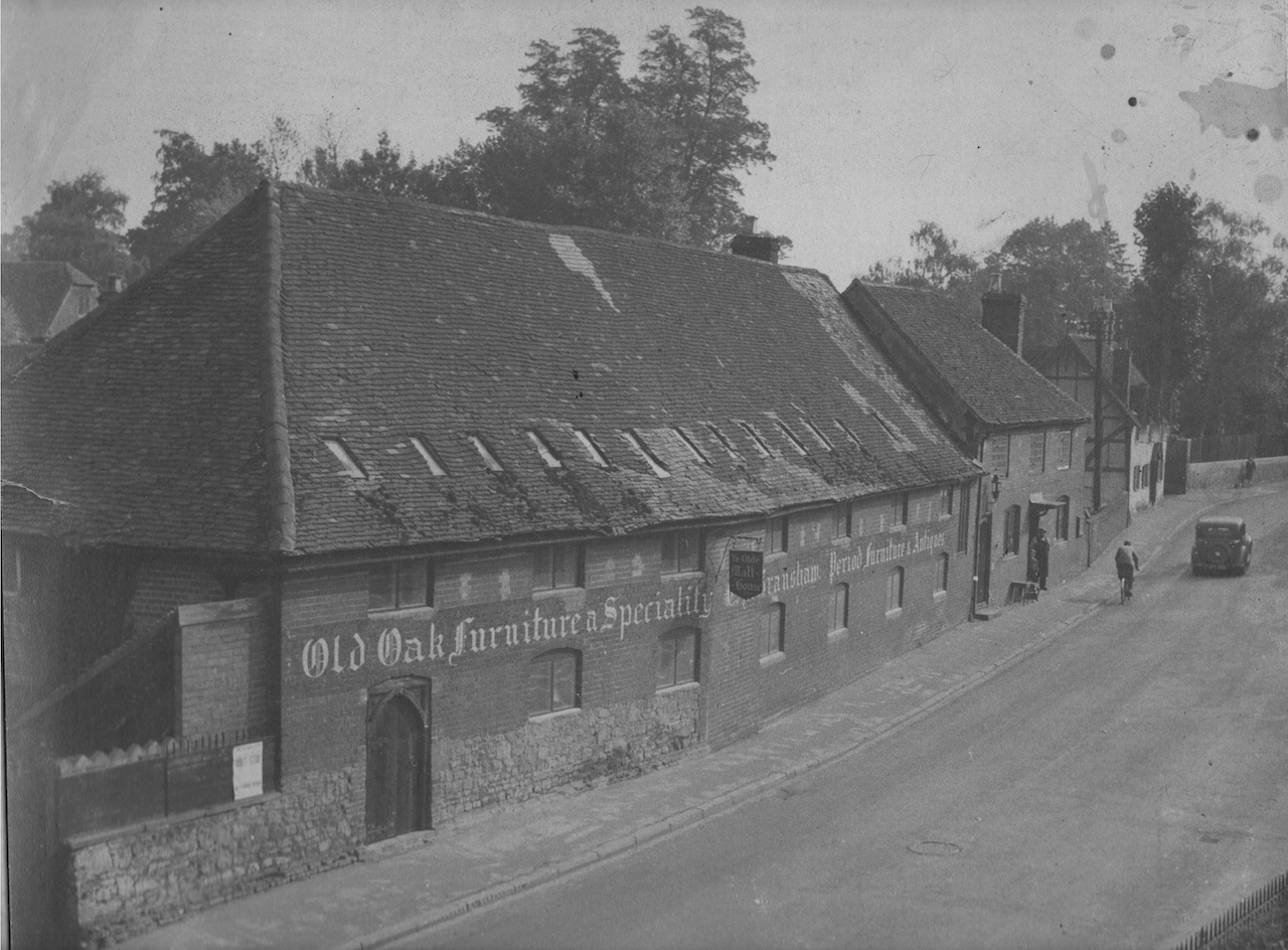
Do you recognise this location near Guildford?
The vintage picture featured this time is rather good. I had not seen this view before until a copy was emailed to me by Mervyn Granshaw.
Do you remember this building and can you recognise the location, about a mile and a half south of Guildford town centre?

Where can this be found?
The quirky picture shows one of several public air-raid shelters built during the Second World War that can still be found around Guildford.
Do you know where this one is, near a public open space and a place used for a type of sport?
If you know the answers and perhaps can add some more details, please leave a reply in the box below. I’ll give the answers in two week’s time with the next images.
Share This Post


Responses to Where Is This? No.285
Leave a Comment Please see our comments policy. All comments are moderated and may take time to appear. Full names, or at least initial and surname, must be given.

I'm living well for nothing at all! (See: No Trifling Matter: Magpie Trapped in Godalming Sainsbury’s)


Next stop, Debt Chasm! (See: We Should All Be Outraged About the Failure to Deal with Legacy Debt)


Wayne Smith
February 17, 2018 at 1:16 pm
I think the air raid shelter is on Merrow Downs, at the back of houses at the top of High Path Road.
Norman Hamshere
February 18, 2018 at 9:41 am
Granshaw’s, antique dealer at Ye Old Malt House in Shalford.
John Lomas
February 18, 2018 at 5:42 pm
I think the air raid shelter is the one at the foot of Merrow Downs off High Path Road.
It is a lot more overgrown than it was back when you posted it in the article asking “Can you Help to solve the mystery wartime air-raid shelters.
Something about the old photo has me thinking St Catherine’s village, on the left facing towards town just after Sandy Lane, probably photographed from upstairs of the Ship inn.
A 62-year-old map shows it like that but an earlier 1935 one shows it as two premises one of which was a post office. The hanging sign seems to say Ye Olde Malt House.
Chris Townsend
February 26, 2018 at 8:28 pm
“Ye Olde Malt House” used to be opposite the present car park of the Sea Horse pub in Shalford, and was run by Ernest James Granshaw & Sons, and before him his father James Thomas Granshaw, who died in 1923.
The antiques business was there for many years, until about the 1970s. The black and white building on the right of the old photo is still there.
The air-raid shelter is not, as I first thought, the one at Recreation Road, but “off High Path Road, near Guildford Golf Club” on Merrow Downs, as I read at https://guildford-dragon.com/2013/02/27/can-you-help-solve-mystery-of-guildfords-air-raid-shelters/
Brian Holt
February 27, 2018 at 4:36 pm
The Street in Shalford.
The picture was taken from the entrance to Shalford Mill looking towards Shalford railway station.
The air-raid shelters are at the bottom of Merrow Downs, just off High Path Road, and near Guildford Golf Club.
They was covered by vegetation which was cleared by volunteers.