- Stay Connected

Socialize

 Abraham Lincoln
If given the truth, the people can be depended upon to meet any national crisis...
Abraham Lincoln
If given the truth, the people can be depended upon to meet any national crisis...

 Guildford news...
for Guildford people, brought to you by Guildford reporters - Guildford's own news service
Guildford news...
for Guildford people, brought to you by Guildford reporters - Guildford's own news service
Where Is This? No.288
Published on: 18 Apr, 2018
Updated on: 18 Apr, 2018
By David Rose
Apologies for the delay in adding a new post – things have been rather busy of late.
However, in response to the previous one there were six replies giving details of an aerial view of Guildford around the 1930s.
John Lomas replied twice, and in his second reply asked about some barrel-shaped roofs on buildings above the almshouses in Bury Street.
These would have been in Millmead and there were some industrial buildings there. A 1935 edition of Lasham’s Directory of Greater Guildford lists in Millmead the Guildford Magneto Works (proprietor J. Sheppard).
John also wondered whether the building seen in the High Street “as a large expanse of white” was a the Lion Hotel. Yes, I am sure that is correct.
Click here to see the previous post and all the replies.
Surprisingly no-one replied to identify the quirky picture with the words on the side of the building: Guildford Workmen’s Home & Coffee Palace.
It is Vaughan House in Chertsey Street. It offers supported housing to those who are single, homeless or at risk of homelessness.
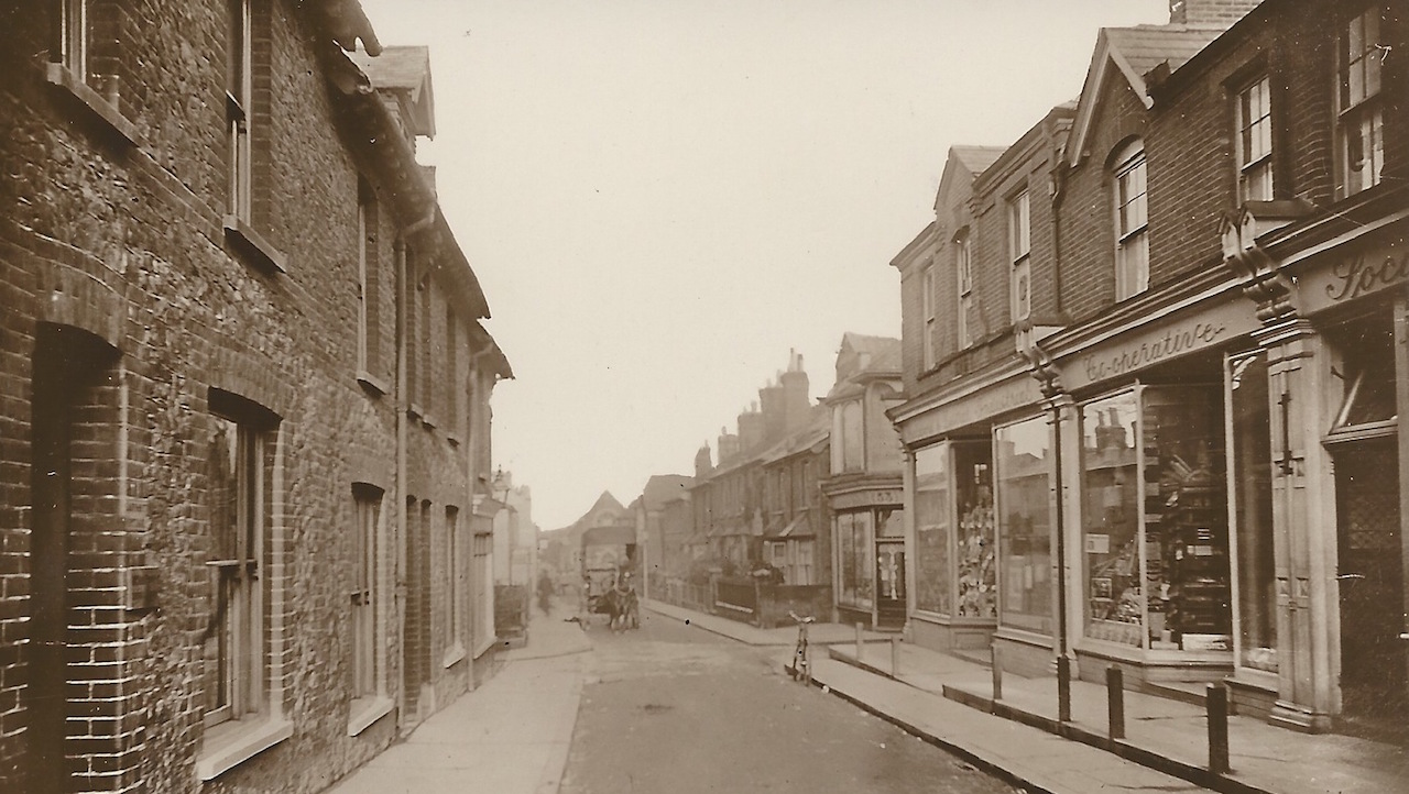
Do you recognise this side street? Like on image to enlarge in a new window.
The vintage picture this time is a view looking down a side street in the town centre that was published as a picture postcard in about 1910. Do you recognise it? Looking further down the road will be some clues.
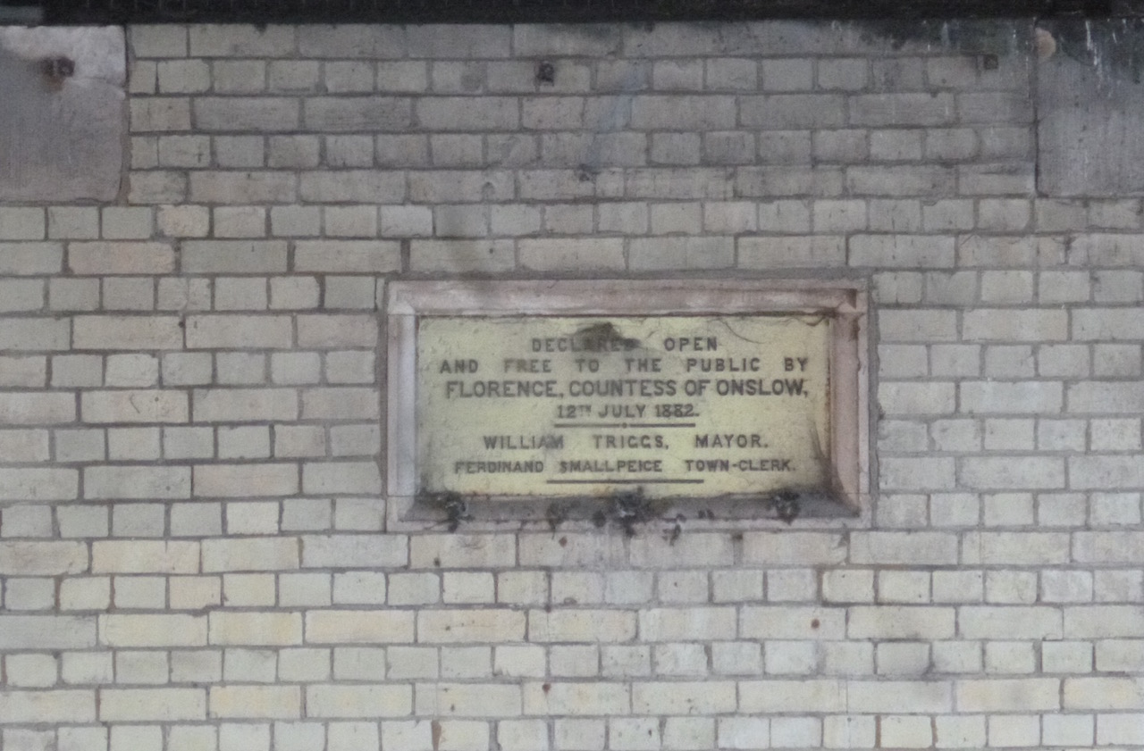
Where can this plaque be found and what does it commemorate?
The quirky picture is a plaque that declares something being opened in 1882. This is in a bit of a strange position, but one of three plaques commemorating the same event on the same structure. What and where is it?
If you know the answers and perhaps can add some more details, please leave a reply in the box below. I’ll give the answers in about two week’s time (hopefully) with the next images.
And please remember to include your full name in the reply box.
Share This Post


Responses to Where Is This? No.288
Leave a Comment Please see our comments policy. All comments are moderated and may take time to appear. Full names, or at least initial and surname, must be given.

I'm living well for nothing at all! (See: No Trifling Matter: Magpie Trapped in Godalming Sainsbury’s)


Next stop, Debt Chasm! (See: We Should All Be Outraged About the Failure to Deal with Legacy Debt)


John Lomas
April 19, 2018 at 10:33 am
Haydon Place with the Co-op on the right. I remember queuing up with my parents in the “dance hall?” at “divi time” to collect the savings they had made over the year.
I think this would have been around late November to early December to encourage people to spend it on goodies for Christmas.
The clue in the background would be the Beverley Hall.
The houses on the left were still there on a 1935 map, so presumably they disappeared when the GPO sorting office was developed.
The shop on the far side of the Leapale Lane corner (built sometime between 1896 and 1916 looking at old maps) is still there and recognisable.
The other picture is going to be something of a guess. I think the plaques are in a public convenience, possibly the ones on the North Street / Ward Street corner.
Around the time of this, there was a William Triggs clock / watchmaker at 120 (pre-renumbering) High Street.
If it is the same William Triggs I wonder if he supplied the original clock on the tower above the toilets?
Christopher Fairs
April 19, 2018 at 3:47 pm
I think it is looking down Haydon Place towards Stoke Fields.
Steve Grove
April 19, 2018 at 7:21 pm
Picture 1. I think this is Haydon Place looking away from North Street with Martyr Road going off to the right.
Picture 2. This plaque is under the bridge in Bridge Street, on the opposite abutment to the towpath.
Steve Munfield
April 19, 2018 at 7:51 pm
I think the vintage picture is Haydon Place.
Dave Middleton
April 20, 2018 at 10:39 am
The street scene is Haydon Place, with the junction of The Bars and Leapale Lane.
The horse and cart is coming up from the York Road direction.
Everything in the photo has gone now, with the exception of the terrace of houses and the shop (now a hairdresser’s) on the right and past the junction.
You can make out the premises of Guildford Action / Beverley Hall in the distance.
The plaque is underneath Onslow Bridge, on Bridge Street and is on the side opposite the towpath, accessible only by boat!
Jules Cranwell
April 20, 2018 at 3:06 pm
The plaque is on the bridge, commemorating its opening.
Sue Warner
April 20, 2018 at 4:28 pm
Is the first picture Commercial Road, Guildford and is the plaque under Onslow Street bridge, but I don’t know why?
Albert Robinson
April 25, 2018 at 3:45 pm
The street is without doubt Haydon Place.
It is recognisable even now but the building on the left and the shops on the right no longer exist.
Beneath the initial part of Haydon Place there are still the remains of the tank traps which were installed during the Second World War.
Chris Townsend
April 25, 2018 at 9:23 pm
The vintage picture shows Haydon Place, looking towards North Place, with Beverley Hall (as I know it) in the distance.
The distinctive shop on the corner of The Bars still stands, as does the row of cottages formerly part of North Place, but the other buildings are long gone.
There is a good Dragon article on the Guildford Co-op here:
https://guildford-dragon.com/2012/08/31/days-of-the-guildford-co-operative-society-and-the-divi/
My guess is that the quirky plaque commemorates the opening of Onslow Bridge. (If not, then Lady Onslow was having a busy day.) Is that plaque viewed from the river?
Bill Staniforth
April 27, 2018 at 5:03 pm
The side street is Haydon Place.
The plaque commemorates the Bridge Street bridge.
Mike Dillon
May 2, 2018 at 7:44 pm
I think the main photo could be looking down Haydon Place towards North Place.
The last shop on the right would then be on the corner of North Place and Leapale Lane.
Brian Holt
May 13, 2018 at 12:08 pm
The picture is looking down Haydon Place taken from North Street end.
On the right were the Guildford Co-operative Society’s shops. The door on the right on the edge of the picture was where you brought bread and milk tokens and pay the tontine money. I used to go there every Saturday morning with my mother.
There was a bakers, butchers, and grocery shops there. In those days they sold everythin.
Where the horse and cart is further down in the picture is where the Waitrose store is now.